I'm continually on the lookout for destinations for my Road Trips, and I'd been looking at White Sands for a couple of years. It's primary lure was that it was "on the way home" (more or less) when I make my periodic visits to southern Utah. When I bought a new car in February I started looking around for a place to test the new ride for Road Trip Compatibility. I'd been eyeing the Big Bend National Park even longer and decided to make it a three leg trip: Austin > White Sands, there > Big Bend, and thence home. Without giving anything away about the destinations, the Road Trip itself proved delightful and my new Santa Fe passed it's most important test to date.

I did my usual planning and programmed the GPS, but I guess I skipped a page or two because I was somewhat surprised to find myself in New Mexico's Sacramento Mountains approaching Alamogordo from the east. This shot is looking west towards Alamogordo, Holloman AFB, and White Sands on the plain beyond that gap. Initially surprised by the fact of the mountains, I decided they were quite respectable mountains, though an occasional tree would have been a nice touch.

I refueled in Alamogordo and breezed on by to the National Monument, just one more Texas tourist, most of whom seemed to be sporting Texas Longhorn tee shirts, hats, and/or car jewelry. It was Sunday afternoon so why not; for those from west Texas, this was the closest approximation of a beach to be found. The sand would have felt right at home in Panama City or Pensacola though the scattered yucca plants might have turned some heads. And then, of course, there was no Gulf of Mexico where the "beach" stopped. But with a little imagination you could look out and see the great blue wave in the distance which was the Sacramento Mountains.

The plan was to see whatever there was to see, then shoot the sunset and, twenty minutes later, turn around and shoot the full moon rising in the east. The potential efficiency to be exploited in the celestial timing of the two events was too much for the planner in me to ignore. I arrived in plenty of time to scout locations and work out details and, indeed, after taking some fairly pleasing shots of the "beach" and its anomalies, I ended up napping while waiting for the sunset. I especially like the backlit shot above.

I was disappointed that, at least from the places I visited, there were very, very few places where the sands were undisturbed by my fellow travelers. I'd had visions of pristine dunes in the foreground of my White Sands Sunset, but every second or third visitor to the Monument seems to bring a saucer of some sort. . . mostly neon-colored Super Frisbees. . . to surf the sandy slopes. Looking out over busily criss-crossing footprint trails, I imagined scores of shabby, barefoot, thirsty survivors, each staggering towards his own mirage - but polite. . . "Beg your pardon." "After you, sir." "Hot, isn't it?"
I'd found a vantage point from which to shoot that, while the view was well-trodden, it was mostly free of actual wandering tourists. I still hoped be able to pass my sunset shots off as me in the wilderness, communing with nature. It's been a long day.
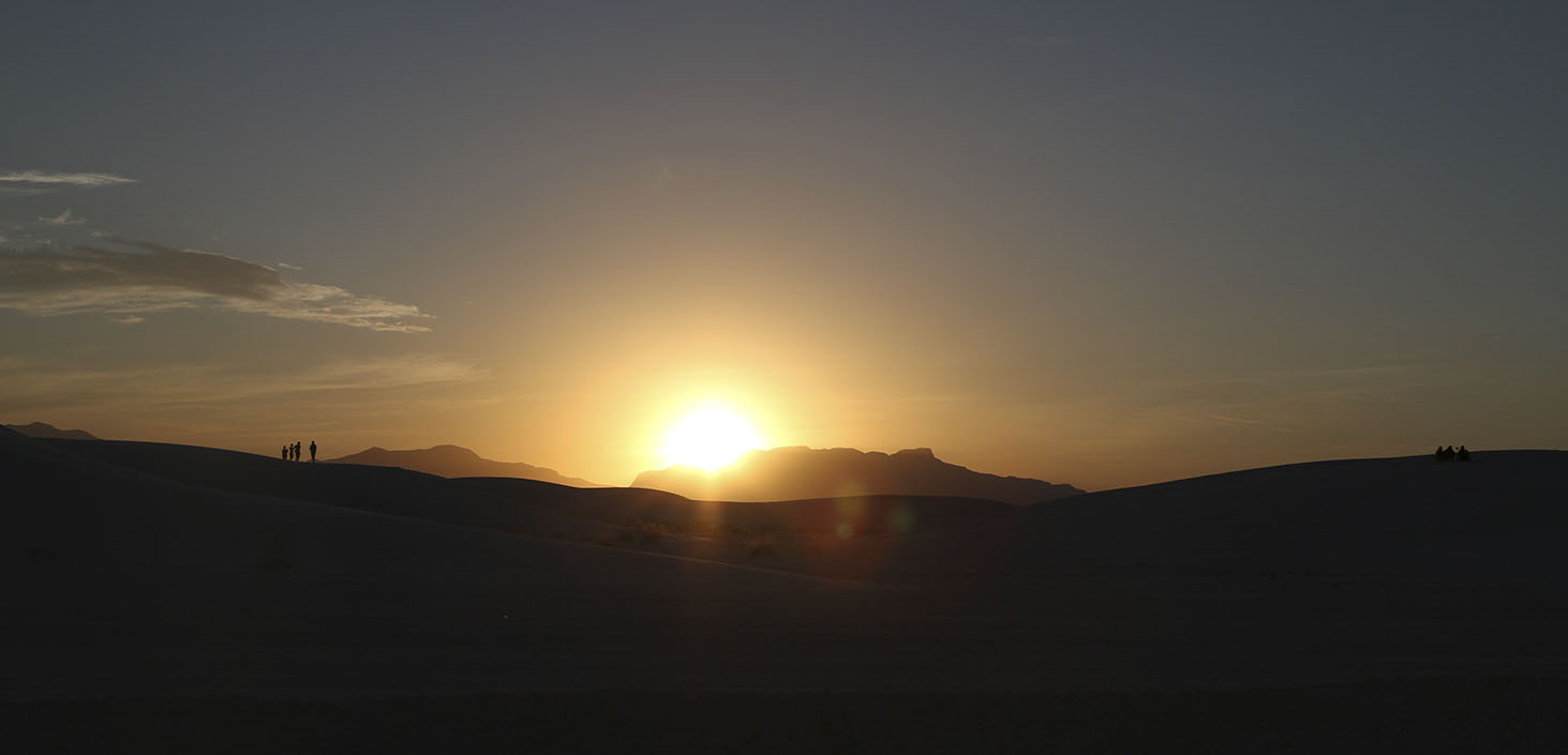
As dusk approached and Sol continued to sink in the western sky, I finally realized the light had changed so much that I needn't have been concerned about footprints in the sand. Absolutely
everything but the few remaining clouds would, of course, be in silhouette against the dying daylight. "The best laid plans. . ." Never taking myself too seriously, I had to laugh when those footprint makers whom I now refer to as "the sand people" rose from the dunes to bid adios to the sun. The four on the left actually began dancing as the light faded. This ain't Key West, but it'll do for New Mexico and you can celebrate anything if you put your mind to it.
No moon rise picture, you say? Yeah, well. The few clouds that had been in the area all day - and should have helped out with the sunset pictures - slipped off to the east while I was napping and, of course, obscured the moon rise. As I drove through Las Cruces and on down to El Paso for the night, the moon managed to clear the scant cloud cover and light my way. So, little turned out exactly as I'd expected, but that's alright. I'll finally see the Big Bend tomorrow after all these years in Texas.