Sunday, May 31, 2015

The 2015 Spring Roadtrip: Cedar Breaks National Monument

I didn't sleep very well in Boise and consequently the drive south through Twin Falls ID and Ely NV was tough. I ended up stopping several times, napping in the Sierra and moving on for another couple hours. I did uncover a weakness in my planning, however. It seems I failed to take note of the route's terrain on this leg and I was actually surprised by the size and scope of the mountains in Nevada. Every time the road I was traveling took aim at a ridge whose upper reaches were encased in the clouds, I was sure that I'd soon be trying to cross the snowy pass. I think my fatigue was showing. As it turned out, I made it to my motel in Cedar City in time to take a two hour nap before checking out Cedar Breaks National Monument for the sunset.

Cedar Breaks NM is about 20 miles east of town and the stretch of I-15 that joins Las Vegas and Salt Lake City. I-15's probably a very nice highway, maybe even a scenic highway, I don't know. I'll continue to bend to my preference for local byways. The view above is the western approach to Cedar Breaks, sometimes described as a mini Bryce Canyon. One's initial impression might suggest that,  however it's really an overstatement. On the other hand, depending on where you happen to be and when, it's (1) easier to get to and (2) you may not have to share it with anybody. Those are a real selling points.

When I arrived, a few hours before sunset, I was still unsure whether there'd be any sunset for me to shoot. I'd not been rained on all day but by the same token the clouds did threaten all day. But being up here alone, it's easy to go with the flow and decide to stick around to see how things turn out.

Besides the red rock sandstone, there were plenty of stands of fir trees, or combinations of fir trees and matchsticks. It didn't look like there'd been a fire recently, maybe some kind of beetle or acid rain. There was plenty of snow still, but none of was on the road (which I thoroughly appreciated).

Sometime between taking the picture above and the picture below there began to be indications that the clouds may break up enough before sunset to give me some color. You never really know about whether or not the color will be there until it starts showing up. It's just a waiting game.

I did appreciate the standing water and melting snow. It makes a good foreground. I was also glad to see the sun making an attempt to break through. Since I was the only one around, I'd have to assume Mother Nature's effort was especially for me, right?

I guess I need to quit imagining my sunsets ahead of time. My imagination works well enough that it seems I'm doomed to be at least somewhat disappointed. On the other hand, I know great sunsets happen and I can increase my chances of catching one occasionally by trying more often. Yeah, that's a plan.

These last two shots were taken at the aptly named Sunset Overlook. It was a very enjoyable afternoon and it made me thankful. Thankful for my jacket with its quilted lining (it was about 40° with a 15 knot wind) and thankful for digital cameras and lithium-ion batteries that let you shoot hundreds of pictures on a single charge. How great is that?!!

It occurred to me, standing at Sunset Overlook, that my plan to come back for sunrise was ill advised. None of the overlooks is called Sunrise Overlook and there's no good spot to shoot the Brakes at sunrise. Instead, I'll give myself an extra hour of sleep - or the possibility of an extra hour of sleep - and head directly to Zion NP in the morning.

Friday, May 29, 2015

The 2015 Spring Roadtrip: West Yellowstone to Boise

This post is going to be short and sweet. You're probably asking yourselves, "Why is he going to Boise?" Good question. Once I'd made the decision to go to Grand Teton and Yellowstone NPs, the pull from an unexpected quarter kind of took on a life of its own. In December 2012 I found the gravesite of a great, great uncle who had apparently gone missing after the Civil War. There are several posts on this blog site recounting the details. Still, as far as I know, no one in the family had ever visited the gravesite. I had found pictures online of the Fort Boise military Cemetery and reposted a few of them when I was writing about this uncle. I found the terrain interesting and thought that I might at some point get a chance to photograph the area myself. So, in planning my road trip, I found myself routed to Yellowstone and looking for an alternate route home, not wanting to re-cover ground I had just seen. Perusing Google Maps it was obvious that I was going to cross into Idaho at some point, probably from Yellowstone's west entrance. That's when the pull started. . . 356 miles to Boise. Well, having come this far, another 6 hour drive hardly seemed critical, and I am on a photo mission. I shifted my third night motel from Idaho Falls to Boise and my fourth night to Cedar City, effecting a bypass of Salt Lake City and set up staging for another visit to Zion NP.

There are some nice mountains between Yellowstone and Boise, but after the last few days I thought I'd be better off if I stuck to the Snake River basin. With the skies I had for this trip, I thought the relative simplicity of the plains landscapes would be more than satisfactory. And, so they were. The shot above,  near St Anthony, Fremont County, ID shows the skies had lost none of their drama.

About halfway to Boise I passed Craters of the Moon National Monument (above). What appears to be turned earth in the middle of the image is actually a lava field. In the 60s some of the lunar astronauts trained here not because it was actually like the moon's surface (the name was coined in the early part of the century in a random remark about the area's desolate nature), but because it was easy to show them just how to search for target moon rocks when they got up there. The skies notwithstanding, I didn't expect to find anything there I'd want to photograph. Keep on trucking. . .

I found Fort Boise Military Cemetery right where I expected to, in Ada County, ID. . . just over the hill and about 2 1/2 miles distant from the state capitol. I'd been hoping all day for the clouds to stick around, but thin out a little bit too, anticipating lots of color and a great backdrop for the cemetery images. By the time I'd been in Boise a few hours I decided I probably wasn't going to see that color. My guess is that the clouds extended far enough west that the setting sun couldn't reach the high clouds over Boise which would have provided the color. Oh well, the best laid plans. . .

Arthur Conlin, son of John Conlin and Sarah McAllister Conlin;
b. 13 Aug 1840, Augusta Twp, Carroll Co, Ohio; d. 06 Apr 1904, Fort Boise, Ada Co, Idaho.
Pvt, Co I, 86th Ohio Volunteer Infantry, Civil War
Pvt, Co B, 170th Ohio Volunteer Infantry, Civil War

Looking west from Fort Boise Military Cemetery towards the federal and state government complex which includes the VA Hospital, Idaho State Veterans Home, Fort Boise Park, Idaho State University, and the US Geological Survey - Idaho Water Science Center. The state capital is probably out of frame on the right, on the other side of the hill.

I hung around for a couple hours till I was sure the skies weren't going to suddenly light up in a symphony of color.

No promises had been made, so I wasn't really disappointed. The cemetery was as peaceful and pleasant as anyone could expect and I appreciated the opportunity to sit quietly, think, and listen to the birds sing.

One of the things that crossed my mind sitting out here was that I still might find more information about Arthur, who had been a member of the Phil Sheridan camp of the GAR (Grand Army of the Republic, a veterans organization along the lines of the VFW, I believe) in Boise before he died.

I need to see whether there's any way to search, or have searched on my behalf, GAR records which are probably archived by the Idaho State Historical Society. I had found some records online, but they were only documentation of the GAR "encampments", annual reunions for Civil War veterans.

Thursday, May 28, 2015

The 2015 Spring Roadtrip: Yellowstone NP

The morning in Grand Teton was very enjoyable, but I probably didn't pay close enough attention to my schedule. Cutting out photo ops in the southern portion of the park moved things along, but when I crossed from Grand Teton into Yellowstone I was still looking for places to save time and get out on the road to Boise. It occurred to me that ever since I was in the Navy I've tended to jam too much stuff into a limited amount of time. I probably ought to keep that in mind when I plan my next road trip.

This view is looking south along the Lewis River, from a roadside turnout just a few miles inside Yellowstone's south entrance. Well above the river, the turnout had a low granite wall to keep cars and people from playing too close to the edge of the drop off. Of course, some people are going to see a wall like that as something to climb on or, in my case for example, something to sit on while angling for a good shot of the river.

I was sitting thus when I took this shot, which really wasn't as good an angle as I had expected. But, you win some and lose some. Sitting on the low wall and straddling it on uneven ground, I found I needed to lean forward to get my weight over my feet so I could stand up. Well, that was when time slowed right down and everything happening at once became a sequence of events.

+++ Bonus Special +++


This satellite shot (above) from Google maps shows the set up. I wasn't really dizzy exactly, but I was off balance. I heard traffic coming up the road behind me and I thought to myself, "if you fall, don't fall left and roll into the road or you'll be just another grease spot." Followed quickly by, "Oh! And don't fall right either or they'll find your carcass a mile or two downstream hung up on the pine branch." So I elected to fall straight ahead. Luckily, I was already so low that the fall was reasonably short. My left knee hit the gravel at the edge of the road and my right knee, my right elbow, and the knife edge of both hands hit the granite wall. That was because I was holding my new camera with my right hand and cradling the lens with my left. That didn't really protect the camera or lens (below) as well as I might have hoped. The bezel of the articulated LCD sustained most of the damage but seems to be superficial. The zoom lens worried me more because, though I couldn't find any scratches on it, the focus ring was jammed. Back in the Sierra I cleaned up the camera and strong-armed the jammed focus ring, took several test shots and found my trust in Canon was not misplaced: everything seem to be working fine.


Camera concerns aside, I took stock of the photographer. Both knees were burning, so I knew they were abraded even though my jeans had not been torn. My right elbow and both hands were a little worse for wear, but all three had quit bleeding. When I looked at myself in the rear-view mirror I realized for the first time that I also had a bloody nose, also no longer bleeding.

I sat there for about 15 minutes, letting my heart rate returned to normal, nibbling on a danish to keep my blood sugar up and thinking about what had happened. The car I'd heard approaching when this whole thing began, came to a screeching halt beside me, 4 or 5 feet away. I waved, to let the occupants know I was all right, and tried to wave them on (who wants to be the cause of the traffic jam in Yellowstone?). Well, that didn't take. As cars started to stack up behind them, the lady in the passenger seat got out to help me up. I remember thinking that the reason they didn't understand my hand signals was probably because they were upside down (?). Of course, I was the one standing on my head, or nearly so. As I started to right myself the lady offered her hand. I handed her my camera then, realizing I still needed help, reached for the proffered hand. She juggled the camera briefly, took my hand and steadied me, then pulled me to my feet (she was really strong, I guess). I assured her that I'd be fine, my truck was right there - 15 feet away, and apologized for the trouble I'd caused. Halfway to the Sierra the kind lady caught up with me, handed my camera back, and told me to take it easy for a while.

Eating that danish turned out to be a master stroke. Sure, my knees burned and the other abrasions hurt, but my blood chemistry stayed put and I didn't have a hypoglycemic crash like I did last October when I slipped on wet leaves and rolled to the bottom of that hill in the Great Smoky Mountains NP. In fact, other than the lingering effects already noted above, I was fine. . . no grease spot; no soggy carcass in the river below. But I need to be more careful or they'll be asking me to surrender my Interagency Senior Pass.

+++ Back to the Tour +++

I'm not exactly sure, but I think this first picture of Yellowstone Lake was taken on the Grand Loop Road looking out over the West Thumb. What got my attention in the first place was the steam rising, apparently from where a hot spring drained into the lake.

This shot - also Yellowstone Lake - was farther north along the Grand Loop, looking east around Gull Point towards the North Absaroka Wilderness and the Shoshone National Forest.

This gentle waterway (here at least) is the Yellowstone River, taken from Fishers Bridge at the north end of Yellowstone Lake. The upper and lower Yellowstone Falls are both a few miles farther north.

Thus far there had been a marked dearth of wildlife in both Grand Teton and Yellowstone. I saw these two bison in the river as I approached a turnout. By the time I got around the corner, they had finished their baths and were drip-drying in the meadow. There were a lot of onlookers at the turn out, but not many with a decent sized telephoto for this scenario. I'm glad I had one. From here through the west entrance I saw bison around nearly every turn. I saw a dozen or so elk, all in one place, and I think I saw a river otter some distance off the road - it could as easily have been a beaver. About a mile from the west entrance I encountered a final bison at the edge of the road. I could've gotten a great picture from 5 feet away, but that was way too close.

I passed various fumaroles and paint pots as the Grand Loop Road approached the West Entrance Road. The picture above was taken from the bridge over the Gibbon River between Monument Geyser and Paint Pot Hill.

This last shot from the West Entrance Road is looking northwest across the Madison River towards the Montana mountains of the Gallatin National Forest.

My roadtrip to this point has been enjoyable and perhaps a little bit adventurous. But I'm going to have to think about the possibility of driving to a destination and staying for a couple of days then driving home. . . sort of like an extended day trip. I don't know how that would strike me. It would certainly be a big change; so far, it's all been about covering lots of ground for me, with efficient routing and minimal dead space. Dead space is boring to drive through and has little of photographic or historical interest. Unfortunately, there seem to be large swathes of it between wherever I happen to be and wherever I want to go. Oh well, we shall see.

Wednesday, May 27, 2015

The 2015 Spring Roadtrip: Jackson WY and Grand Teton NP

I can't believe I didn't bother to take a picture of the snowstorm on that mountain in Utah. It wouldn't have been particularly good. . . the visuals simply weren't there. . . but the hole in the story bugs me. Well, as my Uncle Kirksey would say, "On to bigger and better things."

I harbored no expectations for sunrise pictures the morning of the third day. That said, I was excited about being back in Teton country and anxious to do the best I could will within the constraints of uncooperative weather. I wanted to stick around long enough this morning to give the clouds a chance to lift before moving on north to Yellowstone.

Fatigued from yesterday's drive and sure my sunrise pictures weren't going to happen, I set the alarm to give me an extra hour and, surprisingly enough, I got an extra hour's sleep. I checked out of the motel and headed north out of Jackson. I pulled off the highway at this turnout overlooking the elk refuge just north of town only to find the elk had slept in this morning as well. But the break in the clouds suggested the sun had, indeed, risen and gave me hope for the rest of the day. And, besides, nobody ever turns their back to the Tetons and shoots this side of the valley. Luckily, when I got back in the Sierra, I noticed the gas gauge. Good save, Parker.

This shot tells me that if the mountains are visible at all, it's going to be a good day in the Tetons. I had thought that perhaps finding abundant wildlife might make up for the low clouds early in the day. It didn't take long to disabuse me of that notion. But, when you're working to schedule, you take what you're given as I said above and do the best you can with it.

I wonder if there's a collection of Jackson/Grand Teton pictures anywhere that doesn't include a picture of this barn on Mormon Row. The image of this iconic barn, with the Tetons as a backdrop and, shall we say, "less interesting" skies, illustrates perfectly the definition of "grandeur". That's how something gets to be iconic, I suppose. Cheated of the "full Monty", I took the picture from the driver's seat anyway to remind myself of what might have been, then moved on. If I'd been thinking, I would've taken my time setting up the shot and perhaps used it on some rainy day months from now to create a composite. Yeah, if life gives you lemons, make lemonade. That's the ticket.

As soon as I knew sunrise was going to be a bust, pictures from the Oxbow were going to be the best pictures I'd get in the Tetons and possibly the best pictures I'd get in both Grand Teton and Yellowstone. I was here before, in July 1999. My mother and I were on our way to Coeur d'Alene so she could do some genealogy. The day was absolutely glorious, and this view magnificent. And the only picture I came away with was a very lo-res screen grab from my Hi-8 camcorder, the only camera I'd brought with me. The difference between what I saw that morning and the picture I had to remind me of that morning is, I think, what drives my obsession with digital photography to this day. Whether you like this picture or not, I know my mother would have loved it.

In keeping with my habit of checking for other opportunities before moving on, this picture would be the obverse of the iconic Oxbow image. This is what you get when you turn the Oxbow around and see what's on the backside. Not too shabby. . .


During my pre-trip preparation I had identified with the help of Google Maps lots of places where I expected to find good photo ops. I'm still surprised at how well that works. It's especially helpful to have identified those spots ahead of time when, for one reason or another, you have to modify your plan and skip half the locations. This shot (above), showing the breaking up of the morning clouds and the promise of afternoon's opportunities, is at the north end of Jackson Lake at the dam. This second shot (below), also Jackson Lake, was taken a mile or two south of the first.


Another four or five miles south I made my final stop in Grand Teton. It was hard to pick up and go with patches of blue sky and promise of more, but there is that schedule thing and the concomitant quest for efficiency that drives certain personalities. It's about 10am and I've still got to do Yellowstone and drive 350 miles to Boise.

Tuesday, May 26, 2015

The 2015 Spring Roadtrip: Gallup to Jackson

The first part of the trip, when you start out buried in Central Texas, is always the worst. In this case, headed for Gallup NM, it was 7 1/2 hours through west Texas just to get out of the state. I left Monday morning at six and the only incident of note was the anxiety I felt west of Albuquerque over gasoline. I departed Albuquerque headed west on I-40 with the Sierra telling me I still had over 100 miles range in which to find a gas station. No problema, right? Wrong. This is New Mexico: from here to there (choose any "here" and any "there") is a hell of a long way. Gas stations are few and far between. And it's windy! And for planning purposes, that's always a headwind. The Sierra gives me an estimated range for the gasoline onboard, but it doesn't tell me how it calculates anything, which would be interesting and perhaps even helpful for an engineer. But then, at some indeterminate point, it quits estimating the range and just tells me I have "low fuel". That "low fuel" means different things to different people. What it means to pilots is definitely different than what it means to your average driver simply because everything that happens when you're flying an airplane screams potential doom. But I found an off-brand gas station at a wide spot in the road and topped the 26 gallon tank up with 23.7 gallons. As it turned out, Grants NM was just a few miles up the road and I could have made that too; I just didn't know it at the time. The GPS took me directly to my motel and, aside from the 25 to 30 knot surface winds, things were looking good.

It's 135 miles from Gallup to Cortez in the southwestern corner of Colorado. I was on the road at six the morning of the second day. It was bright and clear that morning and the winds had faded in the night. The traffic headed north was light, but the weird driving regulations on the reservation (Navajo, I think) were more than annoying enough to make up for that. It seemed like it took forever to make Cortez. There were a few pleasant spots where the scenery gave me a shot in the arm. In the picture above, with the dearth of trees, I might have imagined myself in the Scottish Highlands if sage had been heather and had there been any thistles growing on the roadside. If your imagination is up to snuff you should be able to find three castles on that long blue mountain in the background.

From Cortez to Monticello, across the state line in Utah, is only 61 miles. In Cortez it was still bright with only a scattered layer of clouds. Soon after leaving town, however, the sky was much more interesting. To a landscape photographer, an interesting sky can really add drama to an image and I was getting excited about my prospects for the rest of the day. Five or 6 miles from the Utah state line and maybe 20 miles from Monticello I was presented with the "interesting sky" in the picture above. It was like staring into a black hole and it had me seriously reconsidering my plans for the day. Twenty miles from Monticello on a regular day the town would not be visible because of the intervening low hills and shallow vales. But it would be nearly impossible to miss the Abajo Mountains rising suddenly 4000 feet directly west of the city. I love this picture, but without knowledge of the geography it would be merely somewhat interesting.

By the time I'd driven to the outskirts of Monticello, I'd survived transiting the black hole and emerged on the other side where the skies were beautiful, if chaotic, and exciting rather than intimidating. The skies continued to moderate as I drove past Canyonlands NP, through Moab, by Arches NP, west to Green River, and north again to Wellington, UT. North of Green River was new territory for me and exceedingly interesting. The GPS presented me with a glitch in Wellington, telling me to turn into a (dead-end) street while, at the same time, showing my route joining my chosen highway a mile or two north. My familiarity with the GPS has been increasing and I was able to recover on the fly with nary a hiccup.

The picture above shows the skies north of Wellington continued to dominate the scenery. At one point, on a straight stretch of otherwise empty highway, I found myself flying down the road between sandstone cliffs on either side. The tops of the cliffs were connected by a heavy, dark span of cloud directly overhead that presented the feel of speeding through an underpass. The skies in the windshield and behind me in the rear-view mirror were bright blue with billowing white cumulus. I was marveling at the impressive visuals when the overpass suddenly started leaking. I let up on the gas a little and the leak quickly turned from drizzle to pea-sized, then dime-sized, then quarter-sized hail. In two minutes or so, the hail had scoured all former carbon lifeforms (bugs) from the windshield. I don't think my windshield has been that clean since I bought the truck.


These two pictures (above and below) were taken between Wellington and Vernal, UT. The countryside seemed to be changing around every curve. It's hard to imagine these landscapes without the dramatic skies, but I remember the very pleasant feeling of having found a new place to come back to on a future trip in a couple years. Maybe the skies next time will be clear; even so, I suspect this landscape will be worth the trip.


These final two pictures, of Steinaker Reservoir (above), just north of Vernal, and Flaming Gorge Reservoir (below), near the Wyoming state line are separated by about 37 mi. The weather seemed to be holding off at the same time the clouds became more chaotic. Nothing yet suggested, however, that there was anything ahead other than interesting terrain and even more interesting skies. The roads were somewhat steeper, turning and climbing, twisting, dropping out from under you and immediately climbing again. It was almost like being in the mountains. As we (i. e., the road and I) got higher, closer to the ridge lines and hopefully the summit, the wild curves seem to sort themselves out a bit and the drive on promised to be a little calmer.


That should've been a "heads-up". I was still thinking how nice it would be to come back and visit this area again with a less crowded agenda when the hail started again. Pea-sized, like earlier, but this time the hail accumulated quickly on the ground, covering the road. Then the hail was replaced by sleet, which effectively filled in any and every spot on the ground not already covered by ice pellets. Shortly the sleet turned to snow. Since leaving Vernal I had watched the outside air temperature drop from 51 to 41°, then further to 36°, 35°, 33°. . .  About this time I thought, "I'm glad I've got fuel injection or I'd have to be worrying about carburetor ice." When I first started sliding, I didn't think about carburetor ice any more. I'd been following a small SUV with Florida plates up the mountain and the thought occurred to me several times that I'd probably rather be following someone from anywhere else than Florida. It was bad enough that if he slowed down and I lost my momentum, I might very well slide backwards off the mountain. Oh shit! Think of something else.

My friend, who turned out to be from Houston, not Florida (he was driving a rental car), kept his speed up and we both managed to reach the road's summit (the intersection of US191 and Fire Road 018, if you're following on Google Maps). Amenities here at this very inviting overlook, (i.e., a generous, flat parking area) included restrooms, two highway patrol cars, and now us. That made the very real possibility of spending the night on the mountain somewhat less onerous. The cops were telling us the snowplow had been dispatched but there was no estimate of when he might reach us. They also told us, as part of their tourist PR function, "this very rarely happens at the end of May." They left then, one going north and one south, checking the extents of the icy road hazard I suspect. They both came back, the one who'd gone north convinced Houston that he shouldn't have any trouble going north with his four-wheel-drive vehicle. I wasn't quite ready yet but, by the time the second cop returned from the south, I'd watched a fair number of cars and trucks all headed south pass the overlook. He came back and said they were apparently not having any problem and reminded me that the ups and downs to the north were not nearly as steep as those to the south. That was enough for me and, sure enough, once I got out on the road where people had been driving, I had no further problems with sliding.

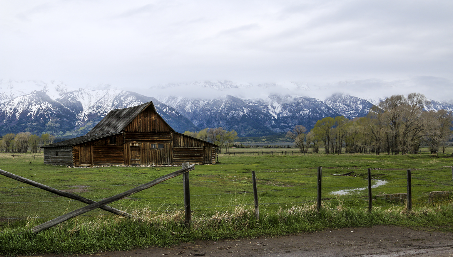
Headed north once more my confidence rose in proportion to the air temperature, which steadily climbed as I came down off the mountain. I took the picture of the flaming Gorge Reservoir and the outside air temperature was again hovering around 54°. I got through Rocky Springs where I listened to the weather report suggesting the precipitation in the area was ending but warning that as temperatures dropped after sundown any standing water on the roads would most likely freeze. Of course, that convinced me to hie myself north to Jackson with all due speed to avoid the Ice Monster. Everything was going along fine and I was making up some of the time I spent idle on the mountaintop. I was thinking about tomorrow in Grand Teton and all the reading I'd done in preparing for the trip. There were numerous warnings about wildlife, the most prominent of which was: Be Bear Aware. Irony is everywhere and doesn't take vacations. I burst out laughing when the bear I was trying to be aware of turned from a grizzly into Smokey the Bear, the county Mountie (this guy was actually WHP ) of song and legend. Apparently, people in Wyoming don't speed much but, on the other hand, they hate wearing their seatbelts. This follow was so surprised to see me wearing my seatbelt, that I got a discount on my speeding ticket. My meeting with the gendarme cost me all the time that I'd made up, but the discounted ticket convinced me to mind my p's and q's the rest of the way into Jackson. When I arrived, the precip had stopped and the air temperature had dropped to 33°. Made it!

Wednesday, May 6, 2015

Leaving Galveston on the Boliver Ferry

Having decided to pass up the chance to hunt for parking in the vicinity of the Pleasure Pier then hike the requisite distance back to the pier (ugh!) to photograph targets of opportunity, there was really nothing left to keep me from heading to the ferry. The wait, queued up for the ferry, wasn't horrible. It was a beautiful day. I was ready to be on my way but unconcerned with schedules. On the other hand, I was still 305 mi from home and had been up since 3AM.

Heading Northwest from the slip near the eastern end of Galveston Island, across the channel on Pelican Island a few points off the starboard beam is Seawolf Park. It was far enough away that I couldn't make out too much detail but I could, and did, record it for posterity. The Navy gray memory on the left is the Edsall-Class Destroyer Escort USS Stewart (DE-238). Center stage is the Gato-Class Submarine USS Cavalla (SS-244). And, what appears to be a black blockhouse on the right, is actually the sail or conning tower of the USS Tautog (SSN-639). Whether or not there's a special connection with these particular ships and Galveston, I don't know. I just shoot what's available. All three were damaged to some extent during Hurricane Ike in 2008, but things have apparently been put right in the years since.

Remember all the pelicans from yesterday's post? Today it's sea gulls. Remember the deplorable lack of sea gulls on my last trip on the Ocracoke Ferry in 2013? My first ride on the Boliver Ferry made up for it. Not having shot birds for awhile and as yet not fully comfortable with the new Canon, I neglected to reset the shutter speed for these shots. The focus was fine, but I really needed a faster shutter speed. Oh well, next time.

The variety of gulls here surprised me a bit. On the North Carolina Outer Banks. . . on my earlier trips. . . there had been almost certainly several different species (herring gulls, ring-billed gulls, and laughing gulls at least), but here all the gulls looked like they'd been cloned, the result of some mad Aggie scientist's fiendish experiments.

But given the paucity of birds on that last trip to OBX, I was happy to have these follow us across the ship channel to the Boliver Peninsula. The protocol here is apparently to feed the gulls from the aft ramp and the kids took their work seriously. If they were slow to part with their treats I have no doubt the birds would have snatched them from the kids' fingers. . . or snatched them and the kids' fingers.

On Hatteras and Ocracoke I saw geese and ducks, herons and egrets as well as gulls and pelicans. Here I saw pelicans at the seawall and over the ferry dock. And I saw gulls following the ferry. No sharing the same skies? Hold on. In the center of the picture, a quarter of the way up from the bottom edge, there's a nineteen-bird formation of pelicans. That will have to do for variety.

Tuesday, May 5, 2015

View Looking Southeast from the Seawall

Let me say this about that. . . I breezed into Galveston from Freeport and found barely ample curbside parking space on Seawall Blvd. That is, there were scads of open parking spaces, it's just that they were barely wide enough for my GMC and I feared for the driver's side mirror the entire 15 minutes I spent watching the antics of the pelicans.

There's clearly not much variety in these shots. There were no clouds over the Gulf so I couldn't do anything about the clear blue skies. Note the tankers anchored offshore, awaiting their turn in the Houston Ship Channel.

I'd have been happier if the pelicans had agreed to dive a little closer to the seawall, but they're looking for fish, not being paid to fly closer to the photographers. A couple of offshore oil rigs and a pair of fishing boats on the horizon. . . that's variety. . . sort of.

Here's what was so compelling about this. . . apparently the fish are plentiful, because as soon as I got set up the pelicans started their reenactment of the Battle off Iwo Jima, kamikazes diving into the sea one after the other.

I tried to get one half in and half out of the water but that was a lot harder than you'd think. That aside, some of the splashes were spectacular.

Well, when I tired of this, I moved on up the boulevard thinking I might get some shots at the Pleasure Pier. But if there was plenty of parking here, there was practically none near the pier. That's okay. I did my recce of Galveston. I'll know what to expect should I find myself here in the future.