Well, this is embarrassing. I had two days of blog posts for my Colorado trip. The first post went out at the scheduled time on Oct 17, and the second apparently stayed in the draft folder. I had scheduled it to go out on the 18th, but forgot to click the "Publish" button. I didn't mean to leave anyone hanging. In any case, I think I can actually launch this post and I'll take the time to see that it goes out this time.
*****
I was glad I'd made the effort to see the Black Canyon from the north rim. It's like the Grand Canyon, I suppose, in that of all the visitors to the canyon, only about 10% have seen it from the north rim. So, to the car and 15 miles back to Crawford, 8 and a half miles of which is graded dirt road. Then 42 miles of lovely scenery along CO-92 to the Blue Mesa Reservoir and another 30 miles on US-80 to the turn-off for the main entrance to Black Canyon of the Gunnison National Park, 7 miles east of Montrose.
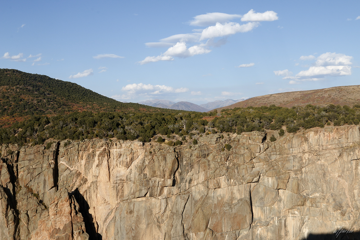
Pretty much as soon as you turn away from the canyon it seems to disappear. The black rock and Juniper crossing the frame above from right to left marks a spur of the canyon. The dirt road on the far side leads to the Island Peaks overlook and some of the pictures in yesterday's post.
Having checked out the canyon and the river, staring down from a couple of the north rim overlooks, I looked up to study the sky for a moment. I was surprised by the wavy clouds filling the space between the standard issue puffy cumulus. I'd never seen that before and made me think of a Vincent Van Gough painting. Yeah, Van Gough would have loved this sky.
These next three three shots were all taken from the side of the road along CO-92 as I made my way down off the plateau to the Blue Mesa Dam on the Gunnison River. If I had the view above to look out on from my porch or a bay window, I think I'd probably spend much of the day scouring the hillside for elk or grizzlies.
There are those wavy clouds again. My first thought was that they must be the mountain waves I'd learned about when I started flying in the mid '70s, but I searched when I got home and found that these clouds are called billows, or billow clouds.
This is my Santa Fe, looking like a Hyundai ad in National Geographic or something. The highlights hide an awful lot of dust after my visit to the north rim - and a cracked windshield, which appeared magically several weeks ago with no star or anything to suggest a rock or gravel incident. Which tire was it? The right front. No leaks. The young man in Goldthwaite did a fine job with that tire repair.
Ah. We're at the south rim of the canyon now, looking north from the Chasm overlook. The National Park brochure says that the width of the canyon here, rim to rim, is 1100 ft.
I'm pretty sure this is the Sunset overlook view looking NW as the river heads off to join the Colorado at Grand Junction. I have other shots of this view from earlier visits, but I'd not been here near sunset before. The time of day (and the season) make all the difference.
This panorama is very similar to the first shot, above, but includes three frames left to right and shows how the canyon hides in plain sight if you're not paying close attention. I also didn't realize just how similar the shots were until a few minutes ago (or I would have pulled one or the other - probably the other).
Last one. I thought I had a good shot of the Painted Wall from the overlook a bit north of the Sunset overlook. This shot (from the north rim) is a panorama (and a better photograph) of the same features that the Painted Wall displays so well at particular times of the day (to other photographers, apparently). The darker gray colored rock (to the right of the grove of fir trees) is Gneiss, "
a foliated metamorphic rock identified by its bands and lenses of varying composition, while other bands contain granular minerals with an interlocking texture. Other bands contain platy or elongate minerals with evidence of preferred orientation. It is this banded appearance and texture - rather than composition - that define a gneiss." (From Geology.Com) The white "paint" on these natural walls of graffiti are Pegmatite, "extreme igneous rocks that form during the final stage of a magma’s crystallization. They are extreme because they contain exceptionally large crystals and they sometimes contain minerals that are rarely found in other types of rocks." - "Some of the world’s best tourmaline, aquamarine, and topaz deposits have been found in pegmatite." (From Geology.Com)
The drive home on Thursday (day 3) was more than I could imagine. Fifteen hours the first day and almost fourteen hours the second day had taken its toll. I was beat! My motel reservation for the next night was in Plainview, TX but I cancelled that and rerouted myself from Durango through Santa Fe, NM, taking the most direct route and cutting out extraneous side trips. If I needed to stop, I could do so almost anywhere. When I left the motel in Montrose, the first surprise was that the temp was 30° and it was snowing. Undeterred, I headed south on US-550 through Ouray and Silverton to Durango - but it wasn't that simple. I had neglected to zoom in on Google Maps in the vicinity of Ouray or I would have realized that the town was in a box canyon at the foot of Red Mountain. To get to Silverton (and eventually Austin) I'd have to climb out of the box canyon via the 23 mile Million Dollar Highway, the defining features of which are narrow roads, no guard rails, no
turn-arounds, and long drops - no reprieves. That would have been daunting, had I prepared for this trip properly. However, I still didn't know about the "hole" I was in. I started out of town and quickly realized I was climbing at a pretty good angle. The light snow was still falling but not sticking on the roads. . . still climbing and now I was noticing things about the road (narrow lanes), no guard rails, no place to turn around. . . yeah, kinda slow on the uptake. Now I know I'm in my own box canyon - there's only one way to go, and that's up (or down if I make another mistake). I remember passing the highway sign calling out 10,000 ft and wondering how much higher. The summit of US-550, Red Mountain Pass, is 11,018 ft so I was there soon enough, but by that time snow had started sticking to the road which left me wondering how steep the descent would be. Worrying at this point wouldn't help a thing, so I just concentrated on sticking to the road. By the time I got to Silverton the snow had stopped, the roads were clear, and the run to Durango was unremarkable. Pagosa Springs, Santa Fe, Clovis, Lubbock, Brownwood (and Goldthwaite), Lampassas, and Austin in just over 19 hours. The adrenaline in my system from climbing out of Ouray lasted the whole day. I never felt the slightest bit sleepy. I got home at 1:15am Texas time, took some melatonin, and slept most of the day. If I'd known any of this ahead of time, I'd have rigged a dash-cam.


No comments:
Post a Comment