Thursday, May 20, 2010

Colorado - the River

I escaped Grand Junction's morning rush hour - such as it is - and found myself virtually alone on I-70, headed to Utah. After about 45 mi, I discovered a 2 mile positional discrepancy in the map database my GPS uses - and missed my turn-off because of it. Another 10 mi to the next exit - this is a RURAL interstate after all; Utah, you know - and the discrepancy was still there but, being flexible, I took the exit anyway.

I stopped as soon as I crossed to the south side of the interstate to get this picture of the La Sal Mountains, about 28 mi south in the very direction I was headed. I had been eyeing this anomaly as I drove, for about the last 25 mi, but wasn't really sure where it was in relation to my planned route. As it turned out, it's about 17 mi ESE of  Moab and dominates many of the area's vistas - as you'll see later. There are several peaks, the highest of which is 12,721 ft. My viewpoint elevation was about 4400 ft.

Eight or nine miles SE of that first viewpoint my route brought me to the banks of the Colorado River and I followed the river on UT 128 into Moab for lunch.The picture above is typical of the land along the Colorado from here all the way past Hoover Dam, though the flooded areas of Lake Powell and Lake Mead are farther afield and much more varied.

At this point - or, at least, now - the Colorado appears pretty lazy and isn't much like John Wesley Powell described his trip down the river in 1869. I saw four rafts that morning, two groups of two. What was interesting about this drive was that the road followed the river from the very beginning of the canyon. There are some wide spots, but for the most part the canyons just keep getting grander and grander as we went downstream. . .

The wall above was different than most on this drive. It reminds me of many of the walls that constrain Lake Powell. From my visit there in 2008, I remember that the chocolate colored stains on the wall are from manganese.

This one caught my attention because of the massive fracture pattern, the sheer wall, and the highlights of the sun with deep shadows.

Wednesday, May 19, 2010

The Black Canyon of the Gunnison

It's amazing, isn't it? I mean this is the early afternoon of the first day out of Cortez. Lots to take pictures of. Northwest out of Ridgeway and headed for Montrose. I've been to Montrose before. Fourth of July, 1976 we were headed back to California. Spent the night in Gunnison, watched bicentennial fireworks at local college, and headed for Montrose the next morning. On the way we took a side trip to see the Black Canyon of the Gunnison. I decided to include the Black Canyon on this trip "for old times sake".

The elevation of Montrose is about 5800'. This picture was taken several miles east northeast of town, looking east from CO 347, which climbs to the National Park atop Vernal Mesa [about 8200']. The northern edge of the mesa coincides with the southern edge of the Black Canyon. The northern edge of the canyon is formed by the Mesa Inclinado - have you got that? It's the clouds I'm excited about. I'm hoping this build-up means a cloudy day tomorrow when I get to Utah.

This shot was taken at Pulpit Rock overlook - looking north I think. I was pleased when I got here, sure that this was where I had taken several pictures in '76 - and that I actually recognised it after 34 years. It's hard to see, but the river is visible in two places waaaaay down there.

You can see it here a bit easier. The river's about 2000' below the edge of the canyon. I can't be more specific because, while the mesa's reasonably flat, the river drops on average 96'/mi over its forty-eight mile run through the National Park. It drops more in that forty-eight miles than the Mississippi does over its entire 1500 mi run from Minnesota to the Gulf of Mexico. In one two mile stretch, it drops 480'. Before dams were built upstream, the Gunnison used to dump 12,000 cu ft/sec through the canyon at flood stage. [That's 2.75 million horsepower. . .] Impressive!

This is the view of the overlook from the porch of the visitor's center. It didn't look either that far or that much lower than the visitor's center when I headed out there - and believe me, I evaluate that sort of thing. By the time I'd started back though, I'd remembered one should never climb any farther down than he's willing to climb up. I kept that in mind the rest of the trip.

This is one view from the offending overlook. It's nice and sharp because, at the time, my breathing was more or less normal. Climbing back to the visitor's center took a lot out of me, but I guess it was worth it - it didn't kill me.

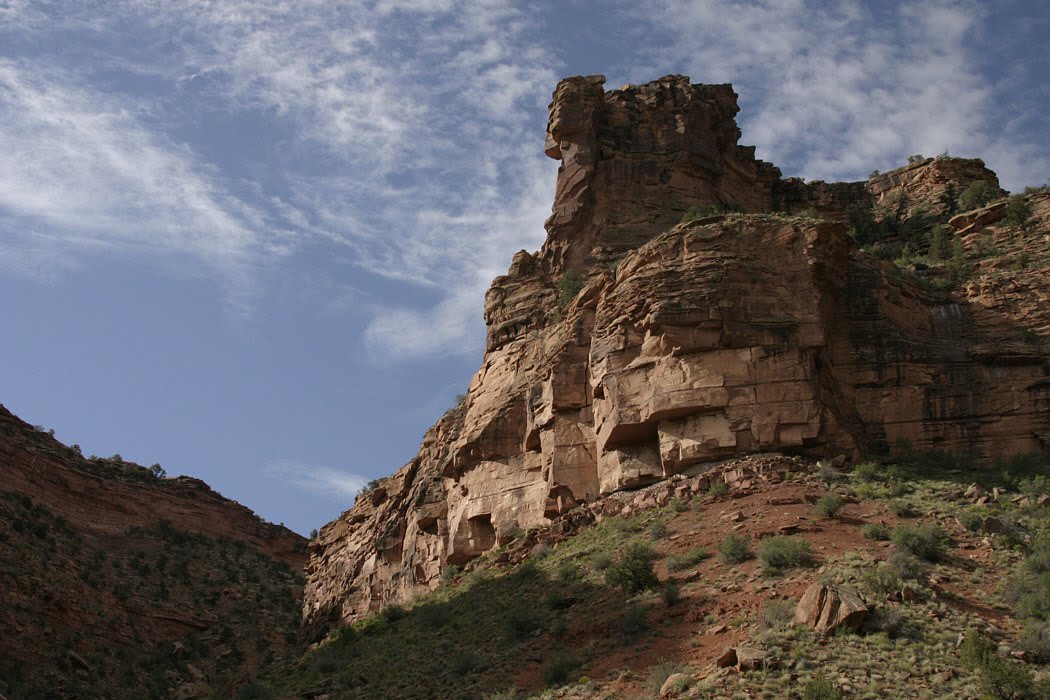
By this time I was completely turned around; you'll have to guess what direction we're looking and, while you're at it, what mountains those are in the distance. I can't help you. I'm fairly sure I'm still on the south side of the canyon, so that'd be Mesa Inclinado across the way, and it's a pretty good view.

Ah, there's the river again, headed west northwest out of the park on its way to Grand Junction, where it joins the Colorado. Note the clouds aren't nearly as interesting out there as I'd hoped. . .

Of course, the South Rim Road just ends at High Point so you have to backtrack to get out. That's why I found myself back on CO 347 shooting those mountains to the east again. In case you're wondering this picture and the first in this post were taken an hour and fifty-four minutes apart. These clouds notwithstanding, I'm thinking it's going to be clear in Utah tomorrow. . . RATS!

Tuesday, May 18, 2010

Back to Telluride

Having given up on making it around the ridge because of the "road conditions" on Last Dollar Rd, I turned around and headed back to Telluride, or at least to the Telluride highway. From a photographer's point of view, there's a lot to be said for retracing your footsteps - or your tire tracks in this case. You drive till something catches your attention and you can find a place to pull over. You get out, shoot whatever it was that caught your eye then, if you're smart, you look all around for anything else of interest - click, click, click. But you still miss an awful lot, surveying only what's in front of you during the time you're driving. By going back the way you came, you get another chance at all that real estate. . .

I'm not quite sure what it is about the picture above - maybe the orange stakes - but I like it.

Recognize these mountains? Yeah, me too. But I missed this composition the first time, probably thinking about the barns I'd just passed. So, I stopped on the way back for the next picture, and found this nice, suitably rustic fence AND a bale of barbed wire.

Here's one of the barns I mentioned - the others are up the slope a little bit. But I was thinking about a composition for a painting, and wanted to get close enough for some detail. What do you think, Stephen?

Alright. Back out to the highway; down the road several miles alongside the San Miguel River and hook a right on Colorado Hwy 62 out of the valley - or at least out of this valley.

This is a view looking east on the road to Ridgeway. Coincidentally, it was taken from the intersection of Last Dollar Rd and CO 62 - where I would have joined the highway if Last Dollar had been passable. The sky kept getting more and more interesting throughout the afternoon.

This was taken at the same stop, but looks southeast. Nice scenery, a good sky - it gave me a sense of the winds aloft and reminded me for awhile how much fun flying used to be. I never flew up here, but I'll bet it would have been great.