Thursday, November 13, 2014

Chimney Rock and Visiting Friends

I felt pretty good the next day, Thursday. No new aches or pains as a result of my tumble. And this day dawned bright and clear. I was going to stick close to town, visiting a few friends from nearly 50 years ago, and wandering about to see how things had changed.

My first trip to Asheville was in 1962 and, from my very first year in school there, I'd heard of Chimney Rock, southeast of Asheville and northeast of Hendersonville. I'd never been there, and decided this was probably the best chance I'd have. So, at 9 o'clock, my friend Debbie picked me up at the motel and we drove to Chimney Rock. The picture above doesn't give a very good idea of how high the observation deck is. You can see in the sign that there's an elevator to the gift shop and deck, and you can climb a flight of wooden stairs to get the grand view at the base of the flagpole. I wouldn't swear to it, but I believe going up in the elevator I heard one of the attendants say that it was 26 or 27 stories high. Yeah, I know. Right?

You'll probably note that there's not a lot of variety in the shots here. The picture above is the leftmost frame of the panorama below. While it's a great view, and I like both pictures, you really need something else to do if you're going to spend the whole morning there.

In this case, it was a good thing I had Debbie with me to visit. It turned out that, because Thursday was National Earthquake Day or some such, state inspectors were on hand to conduct an elevator emergency drill. For most of it, Debbie and I didn't even notice as we reminisced about four decades ago and brought each other up to date on mutual friends and acquaintances. Eventually, we realized everyone was outside on the deck. When someone asked to be allowed back inside to visit the restroom, we learned that drill was still going on. They piggybacked a fire drill on the elevator drill and were in the process of clearing smoke out of the building and resetting the controls for the elevator. Another 15 or 20 minutes and we were on our way down. We'd passed with flying colors.

Next up, Debbie and I headed to Hendersonville to meet Sallie for lunch. Sallie was my French II teacher in my senior year (1965-66). She also taught Debbie, who was three years behind me in school, so it was like old home week. It was good to break bread and get a chance to visit with them both.

After lunch I took my leave of Debbie and Sallie and headed to Arden, where I visited with one of my favorite people ever. Alice is the mother of one of my favorite high school classmates (Anne), former Dean of Women at the University of North Carolina, Asheville, and one of the classiest people I know. I spent the whole afternoon with her and enjoyed every minute. As an extra treat, I was able to visit with her son John and daughter Mary for a few minutes as well. An all around good day.

Wednesday, November 12, 2014

If One Day in the Smokies Is Good, Two must Be Great!

The local weather on Tuesday night promised clearing skies and good weather for the following day. I enjoyed Tuesday so much, even in the rotten weather, that my new plan for Wednesday was to return to the Smokies while the rivers and creeks were still high and the photographs would have better lighting.

Of course, redoing the Smokies would give me two more shots of everything, starting with the Oconaluftee visitor center and back towards Cade's Cove, then returning to the southern terminus of the Blue Ridge Pkwy (near the visitor center) and heading north on America's favorite road. Sorting through my pictures would be confusing, having passed each creek, waterfall and mountain three times in two days. And poor record-keeping wouldn't help either, when trying to identify pictured locations. I could worry about that later.

First stop Wednesday morning was the Oconaluftee visitor center, which I photographed from the same parking spot I had used the day before. It was still too wet to explore the homestead in more detail, but I got panoramas of the same scene from consecutive days for comparison. I've posted many of the panoramas on my Flickr site. To see them, a Google search for "wfp48" should get you there.

This first picture shows how fast and high the Oconaluftee River was early Wednesday morning. I stopped a couple of places and shot some video. I'm not very adept yet at videography, but the soundtracks captured with these short shots of the rivers make even them worthwhile.

This shot, looking south, was taken at a large overlook on US 441 not far from Newfound Gap on the North Carolina side. Higher up the mountain behind me is the Clingman's Dome access road and the North Carolina/Tennessee state line. It was a great place to shoot, because the clouds moving through kept changing the view.

The access road gate was open today, so I decided an excursion to Clingman's Dome was in order. The road wanders back and forth across the ridge and this shot, looking north into Tennessee, was one of these places. It looked completely different ten minutes later when I was headed back to 441. As is often the case, The Dome itself was shrouded in cloud.

This shot too was  taken on the access road close to the ridge. I was on the North Carolina side and the cloud roiling up behind the pine tree in the center of the frame was on the Tennessee side.

To take full advantage of one of these photo excursions, the photographer has to manage his scope. You can stop at an overlook and shoot the grand view this seems to go on forever, then wander around a bit and shoot a small, intimate detail 20 feet away of a stream splashing by a rock. It would be a shame to miss either picture, but changing scope takes practice. It's all about being able to see the forest for the trees. . . and the trees for the forest.

These last two pictures (above and below) emphasize the contrast between light and shadow as your stare into the trees uncovers the layers of the forest. The river in both pictures is the Little River on the road to Cade's Cove.

My return engagement to the Smokies on Wednesday was not without incident. After rejoining 441 and crossing into Tennessee I saw a pull off near the entrance of a tunnel and was enticed to stop by several parking spaces and a pair of small waterfalls at the top of a grassy slope. The change in elevation between the parking spaces and the top of the slope was only about 15 feet. I gathered my cameras and made my way up a gravel path to the base of the waterfalls. I took several shots and a little video and it occurred to me that I should shoot the tunnel entrance from from this higher elevation. I needed a better angle on the tunnel, however, so I moved along the edge of the grassy slope.

I took a shot of the tunnel, but the view was mediocre at best and I was ready to move on. One step on some wet leaves was all it took. I realized my error in judgment immediately when I slipped, cameras in both hands, landing hard on the wet grass and finding myself a couple seconds later lying at the bottom of the slope, marveling at the realization that neither of the cameras sustained any damage at all. When I looked up, a man who witnessed my tumble had just pulled into one of the parking spaces and was getting out of his car. I made it my feet and, on assuring him that I was okay, we went our separate ways.

I continued retracing my drive from the day before, stopping at pull offs, judging various views, taking pictures. Back through Sugarlands to the Little River Gorge Rd on the way to Cade's Cove. It was a beautiful autumn day in the Smokies, I was early enough that traffic was still relatively light, the rivers and creeks were still running high. . . This was great! I was a bit muddy, but not sore in the least after my roll down the hill. What really surprised me, however, was that I was suddenly uninterested in taking any more pictures. Then it hit me. My roll down the hill had given me a shot of adrenaline and that, in turn, screwed up my blood sugar. Twenty or thirty minutes after slipping, I was hypoglycemic. Case solved. The only problem was, I still couldn't care less about taking more pictures. I wasn't hungry, but I really needed something to eat. Tomorrow's soon enough to take pictures.

Tuesday, November 11, 2014

A Wet Start in the Smokies. . .

I thought, when I left on my October road trip to the Carolinas, that I was getting out of Austin just ahead of the rain. As it turned out, however, I was overtaken by the storms in less than 30 miles, in the neighborhood of Georgetown. And, besides the weather, I'd discovered a glitch in the GPS system: in spite of my preparation, the GPS device could access all my waypoints but none of my routes. You know, all the routes I spend so much time developing in my trip preparation. In this case, I had stopped short of testing the routes in the local area, which would have been easy had I thought them necessary. I'm almost 66 now, and learning as I go.

It was an enjoyable morning in spite of the rain as I tracked across Northeast Texas, and Northern Louisiana. Focusing on the traffic and the rain, and the traffic in the rain, I was surprised on approaching the Mississippi River how dark it had become (or how little it had lightened since sunrise), how windy it was suddenly, and how much debris was sharing the sky with the torrents of rain. Several miles straight ahead (I-20 is nothing if not straight) there was a patch of blue sky, the first I had seen since daylight (such as it was). In no time at all, I decided that was where I wanted to be, not here in this nasty storm. As soon as I stepped on the gas I had to come off it immediately. The semi with the apparently empty trailer, ahead of me and in the next lane, was demonstrating what could happen on a wet highway in high winds. While keeping the tractor under control, the trailer swung left like a paddock gate. As quickly as that happened, the gate opened again and the trailer took up its proper position in trail of the tractor. I gave the situation about half a second to stabilize and headed for the patch of blue.

Crossing the Mississippi a couple miles down the road the rain stopped (for all of 43 miles, between Vicksburg and Jackson). It resumed on the east edge of Jackson and continued unabated through my arrival in Sweetwater, TN (which I had come to think of as my homeport for the evening). Reviewing my day, I made a mental note to listen in future to the local weather on the radio rather than allow my CDs to anesthetize my brain. The radio in Vicksburg (and all across Northern Louisiana, most likely) could have been telling me all about the tornado(s) I nearly caught up with.

The plan for Tuesday morning was to leave the motel in time to take pictures of the sunrise in Cade's Cove on the western edge of the Great Smoky Mountains NP. I was third in line at the Cove at sunrise, but the sun never showed up! Not one to dwell on things I cannot change, I blew off the Cove (I'd already been there on better days than this) and just sat in the queue until there was enough ambient light to appreciate driving through the forest and head for Asheville.

All the pictures in today's post were taken from the drivers seat of my Sierra through rain splattered windshields mostly, and occasionally (if the wind and the rain died down enough) through an open window. Some might find the pictures dreary; the lighting was poor, the waves of rain on the glass blurred things. A lot of negatives, to be sure. But I was thrilled to be back in my mountains, even on such a day, and I knew the weather could only get better.

The three things I could concentrate on were the autumn color, the Smokey Mountain mists that give them their name, and the high, fast water in the creeks and rivers, which is unusual in October (one of the drier months of the year in the Smokies). As I left Cade's Cove and the Little River behind me I Turned South at Sugarlands and headed up and south to Newfound Gap where I crossed into North Carolina. I was already thinking about returning here as soon as the rain cleared out and, hopefully, while the rivers and creeks were still running high. How many days that would be remained to be seen.

The first thing I discovered in North Carolina was a gate across the Clingman's Dome access road (as though that was necessary). I could barely see the gate for the clouds.

What I've always liked best about US 441 are the many little waterfalls that come right up to the shoulder of the road, and never more so than today. Typically, tourist traffic would keep me from pulling off to snap a couple pictures. Today, traffic wasn't a factor at all. The picture above was shot (from the drivers seat), across the cab, through the open passenger window, zoomed out as far as I could go. It might have been cropped better had I managed to park at a better angle but, all in all, I think it turned out pretty well.

This is the Smokey Mountain homestead at the Oconaluftee visitors center at the North Carolina entrance to the park. For years it seemed like all my pictures here were taken about high noon because I was driving from Asheville or Atlanta or passing through on my way somewhere else. Today, the rain is steady and the clouds are thick. It looks like early morning, but it's about 20 minutes till 10 AM. If it wasn't so wet, I'd have gotten out and wandered down to the river to see what the high water had done or was doing. But it was warm and dry in the Sierra and I was ready to go see what things were like up on the Blue Ridge Parkway.

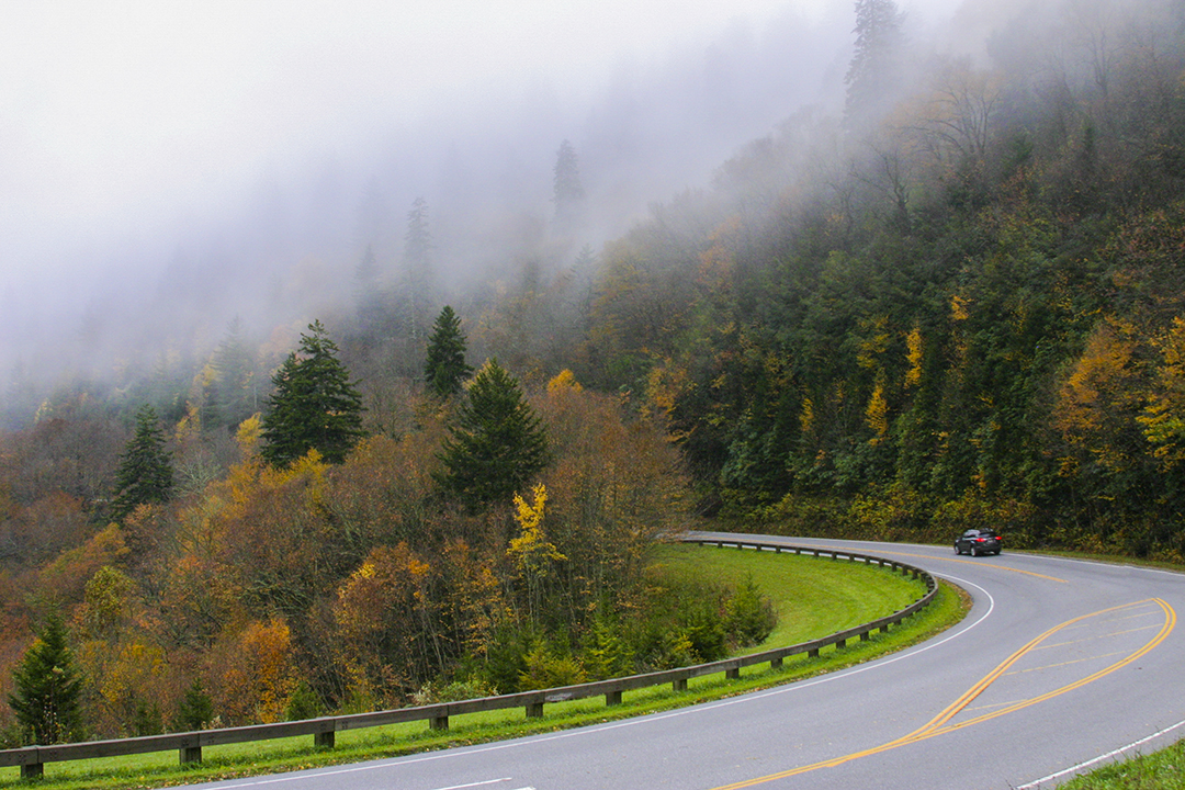
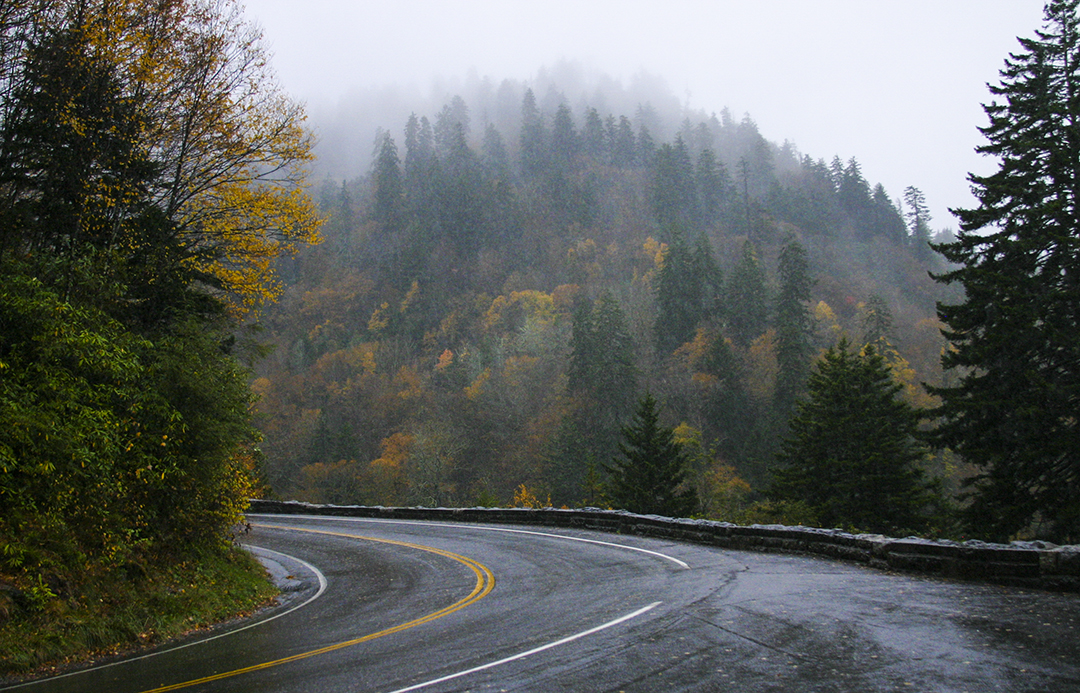
Up on the Blue Ridge things change quickly. You come around a bend at 10 miles per hour in the mist and, if you're lucky, you find an overlook to pull off the road and something in the immediate area to make you glad you've got your camera with you. On a day like today, the overlooks are just a place to park off the road. Vistas that often go on forever, show you on days like today just the inside of a cloud.

Sometimes, in fact, it seems like you have to rush to snap a picture or two before the overlook becomes socked in (an old aviation term usually applied to airports rendered unusable by fog). You might wonder about these pictures; they look like it's been rainy but not necessarily raining at the time I shot them. In each instance I've taken some Photoshop liberties with the picture to give you a sense of how I saw things that morning while minimizing the effects the weather gods were employing to ruin my first day in the mountains. They clearly failed to understand that any day in the Smokies or other Western North Carolina mountains is a fine day indeed.

As I mentioned, things change quickly on the Blue Ridge. The picture above was taken about 11:15 at an overlook some distance south of Balsam Gap. I can't remember its name, but the sign in the center of the picture tells visitors what the elevation is and that this place is the highest elevation on the Blue Ridge Pkwy. Wikipedia gives even more information: "The highest point on the parkway (south of Waynesville, near Mount Pisgah in North Carolina) is 6053 feet. . . above sea level on Richland Balsam Mountain at Milepost 431, and is often closed from November to April due to inclement weather such as snow, fog, and even freezing fog from low clouds." It wasn't November yet and, in spite of the weather, I was surprised at the number of visitors I encountered at these very wet overlooks.

Normally, I go on a blogging binge and put out seven or eight or more posts on consecutive days until I finish my trip report. It's taken so long to get this first post out, I can't guarantee how quickly, or regularly, the rest will follow. They will follow, however, and I hope you'll check back to see how things turned out. (I'll let you know when I've reached the end of the trip.)