Sunday, October 20, 2013

Savannah National Wildlife Refuge

After the morning at Old Fort Jackson and lunch downtown at a sidewalk cafe, we took our tour in a new direction: The Savannah National Wildlife Refuge. Now, it seems to me that much confusion could be avoided if it were called The Savannah River National Wildlife Refuge. You see, it's named Savannah, but located across the RIVER in South Carolina of all places. I mean, wouldn't you look for something named Savannah in Georgia? I'm just sayin'. . .

In any case, the temperature was mild (by Texas standards), nearly cloud free, and the countryside was very pleasant, if a bit flat. The marshes were extensive and "open water" seemed to invite lily pads. But it's a wildlife refuge and I suspected the lily pads were simply camouflage for 'gators and other things that would "get you" if you wandered too far off the beaten track.

Alert to all forms of wildlife, we came across this butterfly. There were also a few wading birds that seemed to keep their distance from the roadway. The only "wildlife" we saw in abundance were red winged blackbirds. I was really wanting something exciting to shoot, but this seemed to be a bust for wildlife.

This road looked promising, with its deep shadows and Spanish moss. Maybe we'd find snakes or something hanging from the trees as well. . .

Naw, but Darin opened the sun roof and I took a few shots of the canopy. I like the picture okay, but only see the dearth of wildlife.

Finally! A great croc shot - whoops, 'gator shot - and in a Burnt Orange waterway! Making up for the slow beginning, perhaps? Okay, Savannah NWR, I'm mollified.

Here's a smaller one (see the inset for more advantageous lighting), just waiting for an unwary passer-by. Perhaps something plump, with feathers, with stilts for legs. Yeah, that's the ticket. Unfortunately, visitors in general (and this one in particular) seldom have the time or the patience of an alligator to catch a Mutual of Omaha moment.

Having seen a few gators now, I began to appreciate the drive a bit more and realized there was probably a lot more going on right in front of me than I could see. It was certainly a pleasant afternoon drive and we capped it off with a stop on the way home to Leopold's Ice Cream Parlor, downtown. I also picked up a couple bottles of hot sauce for my son in Australia from Wiley's Championship Barbeque. Darin and I had eaten lunch there yesterday and it was, without a doubt, the best barbeque I've ever eaten in my life.

The next morning at 6:00, I departed in the dark headed west for home. I'd originally planned to stop about half way, in Biloxi, but I'd been gone nearly three weeks now and  really wanted to get home. I stopped for a brief nap just east of Defuniak Springs, FL, and that was enough to carry me through some monsoon-like weather in Louisiana and east Texas about sunset. I pulled into Austin just after midnight, and the 2013 East Coast Road Trip was history.  I didn't necessarily replace all the pictures I lost with the computer crash, but I got some new ones to keep me busy for awhile. It was terrific, visiting with those family and friends I got to see, but there were a lot more who were skipped, to my regret. Perhaps I'll be able to catch them on the flip side. . .

Saturday, October 19, 2013

Old Fort Jackson

I had done my homework before the trip and identified Old Fort Jackson as a likely spot for some good pictures. Darin, probably remembering our previous trip to Fort Pulaski, also suggested a visit to Old Fort Jackson. We couldn't both be wrong now, could we?

Smaller than Fort Pulaski, Fort Jackson occupied the single choke point for traffic up the Savannah River to the city. The site had been identified by 1777 and was the location of "The Mud Fort", manned by Captain Lee's artillery unit in the Revolutionary War to fend off the expected British sea-borne attack. Conditions were so unbearable that, when Captain Lee died of malaria, the position was abandoned, even before the British approach. Savannah was easily captured in 1778 and given up by the British shortly before the end of the war.

The masonry fort was authorized by President Thomas Jefferson and building began in 1808 under supervision of Army engineer, Captain William McRee. He was transferred in 1812 and the new fort was garrisoned by US troops and Georgia militia during the war of 1812. The fort was named for James Jackson, a former British subject, who rose to the rank of Colonel in the Continental Army and accepted the surrender of Savannah from the British near the close of the war. He later served as US Representative and Senator, as well as Governor of Georgia. Ongoing improvements were made between the War of 1812 and the Civil War. The fort defended Savannah from Union attack until being abandoned before the arrival of Gen Sherman in December 1864.

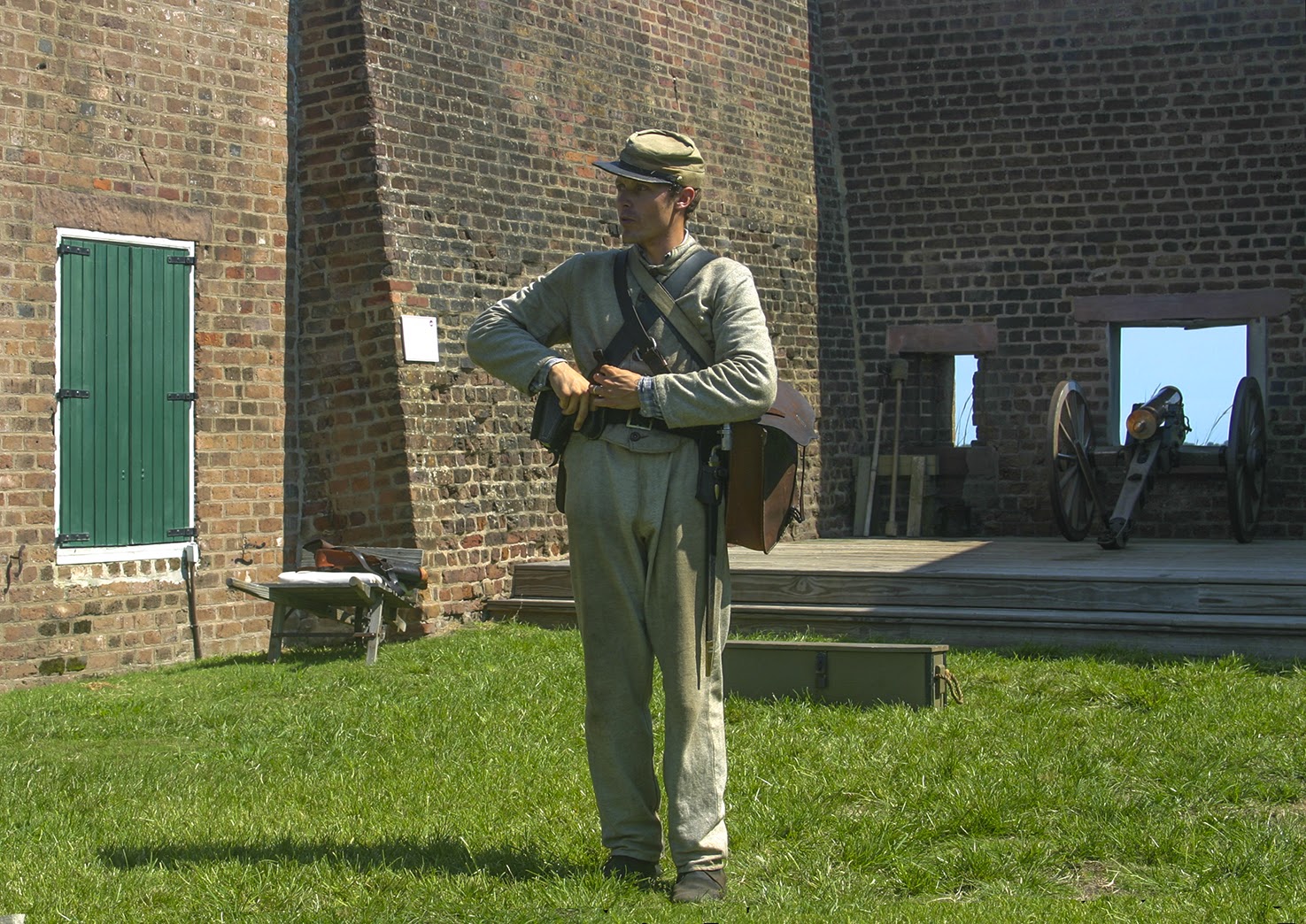
Darin and I explored the fort early, then waited for the scheduled artillery demonstration at mid-morning. We watched young Private Pearson or Pittman or something (sorry, I can't find my notes), CSA, go about his morning business. He was affable, asked where we we from and, when I told him Texas, he responded that General Lee was known to hold Texans in very high regard, having told his entourage, "Texans always move them," [the enemy].

He asked what work we did, and I told him we were both aerospace engineers. Pvt Pullman looked puzzled for a moment (really!) then said, "I heard tell about some fellas floatin' around in hot air baloons. That kind o' stuff?" He stayed in character all morning long. "Yeah, that kind o' stuff," as if I could say anything else.

Pvt Pendleton, still the only person who clearly belonged here, beat "Assembly" from the parapets. Eventually, he attracted, if only loosely assembled, his "troops" - nearly worthless civilians - and began his artillery instruction. He quizzed his charges regularly on the lesson, to make sure they were paying attention.

They descended to the courtyard at Pvt Paxton's command and he continued, the subject now was the field artillery shown, a 12 lb Howitzer or 12 lb Napoleon (I think).

After explaining its uses, Pvt Pinkney addressed ammunition (shot, shell, case, canister, and grapeshot), then hand-picked (drafted) a gun crew from his very inexperienced troops and the gun drill started in earnest.

A pretty sorry lot overall, but Darin (in the red ball cap) stood out as the "shooter" (his honor would be to pull the lanyard, firing the gun). Pvt Pinder kept tight control of his men, insisting that as the engagement progressed, casualties would require the remaining members of the crew to assume the duties of fallen comrades. . .

Just pay attention and follow orders. A typical gun crew could fire once every 30 seconds on average. After the first attempt with his new crew, Pvt Penderghast announced a time of 37 seconds, and averred his belief that they could do better. On their next attempt, the crew took 23 seconds and Pvt Peterson seemed to "choke up" as he allowed as how this was an exceptional improvement. The crew was allowed to be at liberty for the remainder of the day, and the troops were dismissed.

I wish I could remember this young fellow's name. He was excellent in every aspect of his behavior. I guess he should have been; when asked, he said he'd started as a 13 year old drummer boy in 1862. He's learned a lot in 151 years.


Friday, October 18, 2013

Tybee Island, GA

On taking my leave of Charleston I made my way south on US17 to Savannah to visit my friends Darin and Jennie. I worked with Darin at Lockheed before my retirement and his departure for Gulfstream. Jennie works for the Leukemia Society. With both of them still working, Darin was kind enough to provide lodging and take a day and a half off to explore the area with me to boot.

Our first stop for pictures was a city/county fishing pier just beyond the Lazaretto Creek Boat Ramp where old Highway 80 crossed the creek. Opposite the pier, on the east side of the creek, are a couple of marinas. I don't know how much business they do, but the boats left at the dock are always good for several shots. The bridge in the background carries the Islands Expressway/US80 traffic to Tybee Island.

The Lazaretto Creek Marina is the southernmost of those clumped opposite the pier. The various channels within a mile or so form a veritable maze. Though this one is most likely Lazaretto Creek, Google Maps has it labeled the Wilmington River. In any case, the marinas are on Tybee Island, which means there's another lighthouse nearby.

Last time I visited, in 2010, I got some good pictures from Fisherman's Walk, but Darin wanted me to see the village Pavilion and fishing pier. The high winds promised lots of wave action at the beach and we weren't disappointed.

While the OBX wading birds were holed up in Charleston, I discovered the pelicans had come all the way to Savannah. These six were practicing low level tactics among the waves. Ask an A-6 or F-111 driver and you'll find terrain following takes intense concentration, and a great terrain following radar (TFR) helps a lot. These pelicans do it with the obstacles constantly moving! Okay, they're not doing it at a few hundred knots, but still. . .

Finally! The payoff: Tybee Island Light, with the most beautiful lines of any lighthouse I've seen or heard tell of. And, to top it off (literally), a fantastically dramatic sky-full of clouds.

Thursday, October 17, 2013

Charleston, 2013

After two days on the Outer Banks, I made my way down to Wilmington and visited with Joe Vetter at Wrightsville Beach. Joe is and always has been my favorite raconteur. But the visit was all too brief, since he still works and I'm fully committed to my retirement. On to Charleston. . .

I arrived in time to go with Tony to pick up his boat (no, that's the USS Yorktown) at the dealership. We spent a fair amount of time launching or loading the boat at Remley's Point, but it all worked out and it was good to get out on the water. Yorktown was a great background for the sailboats, and my taking pictures didn't even elicit a response from Homeland Security.

That's good, because before cruising the main harbor we'd made a speed run up the Cooper River, checking out the work Tony had just had done on the boat. We got up river far enough that, when we saw some dolphins, we shut down and drifted a bit while we ate our lunch. Seeing dolphins (at the distance we saw them) is really over-rated, but I broke out the Canon and snapped a few shots. When I returned to my sandwich, I noticed over Tony's shoulder, there were two submarines tied up at a small naval facility I was unfamiliar with (I swear I didn't know it was there!). Anyway, without a thought, I picked up my camera to take some pictures. Looking at the subs through the Canon's viewfinder, I thought, "What the hell are you doing?" And, sure enough, when I lowered the camera the Security boat was approaching at speed. I'm sure Tony could only see visions of his new boat - impounded. I regret any anxiety my actions may have caused. The patrol boat slowed once Security saw we were aware of their presence. It was pretty clear that we weren't needed any longer and we decided it was probably a good idea to depart. . . slowly. . . with our hands up. . .  Well, maybe not with our hands up, but we left, and they didn't follow us. I told Tony they didn't need to follow us; they could track us back to Mt Pleasant with their satellite cameras.

We then headed for downtown Charleston, since I'd never seen it close-up from the harbor. On the way to the Battery we passed this lovely ship. . . a schooner, I believe. . . but definitely not a submarine!

The clouds were great for a photo excursion. That's the US Customs House on the right, a block or so beyond the cruise ship landing, and Google Maps tells me the steeple belongs to St Philip's.

The sailboats here, darting hither and yon in front of "Rainbow Row", were quite picturesque. The white steeple just right of the picture's center is St Michael's.

I really like this bridge over the Cooper River, though it always spurs quips from Tony. During its construction I noticed something as we passed underneath it that baffled me. And baffled, I made some comment about whatever it was "not looking right". Ever since, Tony never fails to remark that - somehow - the bridge is still standing. I just wish I could remember what it was that caught my attention that day.


All those birds, the ones missing from the Outer Banks? Apparently, they were down here on an extended summer vacation on the marsh.


It was kind of them to cavort for my camera. I'd expected them to fly off and leave me sitting on the pier. Instead, I clicked away, wishing I had gone ahead and bought that new, longer, zoom lens before my trip started.


This picture of Satchel marks my road trip's greatest coup. Satchel, you see, has a feline characteristic at odds with his canine nature: utter indifference to the affairs of men. Heretofore, he never seemed particularly pleased or annoyed by my presence, but he would invariably get up and walk out if I picked up my camera. By the end of this visit, however, he would magnanimously raise his head and stare directly at the camera. But, for the life of me, I couldn't get him to either smile or say "cheese".

Tuesday, October 15, 2013

Sunset, Ocracoke Island

I guess I could have stayed in the village and tried to shoot the sunset from there, but with the nearly empty harbor and dearth of places to set up a spot to shoot from, I repaired to the beach access boardwalk just north of the Ocracoke airport and concentrated on the changing light.

I was blessed this evening with a terrific sky, full of clouds. . .

. . . and the dunes towered over the boardwalk in places. I could get these low angles easily.

You spend this time constantly taking pictures. You know the sky's "pretty" but, when you're done, you want to be able to go through a number of shots for comparison and choose the "prettiest". I love this one with the boardwalk snaking across the shadows in the bottom of the shot while the sky stands out, big and bright.

The clouds are scudding by and the light's changing more quickly with each passing moment. You don't have to move around much to get an album full of shots.

But sometimes, when you've been twisting left and right on a bench, it pays to get up and turn all the way around for shots with a completely different look.

Time to head back to Hatteras; I snapped one last shot from the parking lot with NC12 in the foreground.

When I got to the landing, I found myself in line, waiting for the free ferry between Ocracoke and Hatteras. I hadn't put up my camera yet, so I got another "one last shot". . . this time of the ferry at dusk.

Monday, October 14, 2013

Walkabout on the OBX

The chronology of all this is muddled a bit, but that's why I covered the comings and goings in "The Drive" posts. So, the sunrise shots actually followed the sunset shots, but who's keeping track?

When you get right down to it, once you've shot the Cape Hatteras light a few times, the surf (if it's up), and some sea birds (if they're around), there's not much more to shoot around Buxton. You may as well get on the ferry to Ocracoke, which is more picturesque, if not more vibrant. Of course, when you get home, you can play with the shots a bit and squeeze all sorts of enjoyment out of processing your photographs.

Parking in Ocracoke seems to have gone the way of Harpers Ferry. Nobody cares too much whether a visitor with a camera can pull off the road, take a few shots, and move on. . . they all want you to buy something. This is about the only angle a visitor can get on the lighthouse here, though I did see a picture yesterday taken from the beach. In pictures from the village, the light barely peeks out above its neighbors. If you can spot the light, you're satisfied with the picture; if you can't, you feel a vague sense of loss.

The sheltered harbor at the center of Ocracoke village is called Silver Lake. It sounds idyllic, and it is. From a photographer's point of view, however, it starts looking empty by mid-September, after summer's continual comings and goings of cruisers and sailboats and the associated hubbub.

But you can't ignore the miles of beach, sand dunes, and sea oats. . . nor would you want to. Given interesting cloud patterns to emphasize the changing light you can include or take away sea views, birds, or human points of interest and still have photographs that work.

Sunday, October 13, 2013

Sunrise, Cape Hatteras

Shooting at sunrise isn't a lot of fun but, on the other hand, it can be very satisfying. If you're inexperienced, as I am, you fiddle with dials and buttons in the dark and eventually you see that the camera is, indeed, recording something like what you're seeing. Some study and preparation would help, of course, but I'm an old dog and such new tricks don't come easily.

This is the first shot that actually registered that morning, and the shutter speed was slow enough that the wave action was blurred. It was also a lot darker than this would suggest, but that's okay. My first shots in 2010 surprised me with lots of sea birds wading in the shallows - this year, it's fuzzy water. It's all good.

I chose these three simply because I like them. The first was taken at 5:23 and the last one (which actually was the last one) was taken 31 minutes later and the image numbers indicate I took 54 shots. Oddly enough, the middle one was taken 15 min after the first and 16 min before the last. The ocean was changing constantly, the light was changing progressively, and I was mindlessly changing camera settings occasionally (just to mix things up).

I spent a couple days working with them in PhotoShop and I'm pleased to report that I can now "fix" most of the things I screw up with my constant fiddling. Like a lot of things, you don't necessarily need to study something if you're willing to spend the time playing with it afterward. My biggest problem in this case was the internal fight between my engineering nature and my artistic nature. Having watched the sunrise steadily progress, my engineering side wants to see a series of pictures showing how the changing light evolved this particular morning. My artistic side, which won out, looks at each image as a discreet example of "a sunrise". I like 'em; I hope you do.

Saturday, October 12, 2013

The Lighthouses

Each of these photographs was taken on the first day of my recent Outer Banks visit. Each of the lighthouses has its own individual history as well as a shared common history with the Lighthouse Service (and its predecessors), which merged with the Coast Guard in 1939. North Carolina lighthouses are addressed  in several places, among which is http://www.uscg.mil/history/weblighthouses/LHNC.asp

*****

Currituck Beach Light

Construction: Brick
Tower shape: Conical tower
Height: 162 ft (49 m)
Year first lit: 1875
Automated: 1939
Original lens: Unpainted red brick with black lantern house
Range: 18 nautical miles (33 km)
Notes: Between 1980 and 1991 the lighthouse

underwent renovation performed by The Outer Banks Conservationists (OBC).


Bodie Island Light

Construction: Brick
Tower shape: Conical tower
Height: 165 ft (50 m)
Year first lit: 1872
Markings/pattern: White and black bands with black lantern house
Automated: 1940
Original lens: First order Fresnel lens, 1872
Range: 18 nautical miles (33 km)
Notes: Restoration between 2009 and 2013. Relit

April 18, 2013.

Cape Hatteras Light
Construction:Brick
Tower shape:Conical tower
Height:210 ft (64 m) (current tower)
Year first lit:1803
Markings/pattern:Black and white spiral bands with black lantern house
Automated:1936 (skeleton tower), 1950 (current tower)
Original lens:First order Fresnel, 1870
Range:24 nautical miles (44 km)
Notes:Current tower moved 1/2 mi inland in 1999.

Ocracoke Light
Construction:Brick w/ mortar surface
Tower shape:Conical tower
Height:76 ft (23 m)
Year first lit:1823
Markings/pattern:White
Automated:1955
Original lens:Fourth order Fresnel, 1854
Range:15 nautical miles (28 km)

OBX, The Drive - Part B

Referring to yesterday's post, each of these photographs was taken the same evening running back and forth between Hatteras and Ocracoke. The following morning I made the ferry trip again to catch the 10 o'clock Ocracoke to Cedar Island ferry.

I'm not sure how many ferries they have on the "free run" between Hatteras and Ocracoke, but all three of my runs were on the Chicamacomico.

I had really looked forward to shooting (pictures of) the seagulls and pelicans on the ferry trips. There was only one problem with that. . . there weren't any birds within range. I don't believe I've ever seen a ferry that didn't trail seagulls for half a mile or more. I felt cheated, somehow. I had to settle for a shot of these four fishing boats returning to Hatteras as though someone had sounded a dinner bell.

Sure, Croatoan has her seagulls, but where are the ones assigned to Chicamacomico? Not only were the seagulls missing from the ferries (all but Croatoan), there seemed to be a widespread dearth of avian activity ashore as well. That included the two and a half hour ride the following day to Cedar Island. What's going on?

I checked in at the harbor and made reservations for the 10 o'clock ferry in the morning. It being September, rather than July or August, there were few sailboats at anchor. You think they took the birds with them when they left? Nah. . . probably not.

After dinner in the village, I searched high and low for shots of the lighthouse and the harbor, then I stopped at the beach access just north to shoot the sunset. If I was going to shoot the sunrise at Hatteras, it seemed only fair to shoot sunset at Ocracoke.