Monday, May 24, 2010

A Speed Run Through Mesa Verde

The last picture in yesterday's post was taken about 4:30 in the afternoon, and I decided I'd move on south and return to Canyonlands' Needles District via a back road I'd identified on Google Maps. That plan would take me to the widely separated Looking Glass Arch, and Hatch Point, and Needles overlooks, over about 87 miles. I turned off the highway and re-entered Canyonlands on Looking Glass Rd. Guess what. Google forgot to mention was gravel. About two miles of washboard road - and the number of visitors I'd already encountered on the Island In The Sky - convinced me that I'd had enough, and it was time to adjust "the Plan". Remember though, it was my first visit to the Needles in 2008 that impressed me so much I had to come back; a reminder - if one is needed - that the conditions of the visit are all important, and you can't control all the conditions.

Skipping the plateau overlooking the Needles, was okay. I'd just take UT 211 into the canyon itself, getting pictures of the ancient petroglyphs on Newspaper Rock and checking out the Needles and other features on the canyon floor as the light changed in the late afternoon. A new opportunity. Traffic picked up as I headed south on US 191 and I never saw the 211 turnoff. Other signs were all there though - things aren't falling into place - it's time to call it a day. New Plan: spend the night in Cortez (still about 75 miles away) and check out Mesa Verde National Park in the morning.

*****

When I first discovered Google Earth, one of the tidbits I came across was that in 2000, Mesa Verde fires in July and August caused destruction that, so far as I could see, it still hadn't recovered from. I'm less interested in archaeology perhaps than in photography and geography/geology and now, beginning my fourth day on the road, I'm more than ready to get back home.

So, when I encounter road crews and sections of one lane road a couple miles into the park, I consider turning around and demanding my money back on my way out. I am able, however, to cool my jets and remember the only schedule I have is in my mind. It's a beautiful day - I should enjoy it.


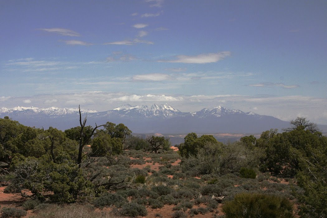
On the climb up from the valley floor, between sections of road under repair, I found the Montezuma Valley overlook which provided farewell views of the Abajo Mountains (above) and the La Sal Mountains (below), both ranges in Utah and 70 and 95 miles away, respectively.


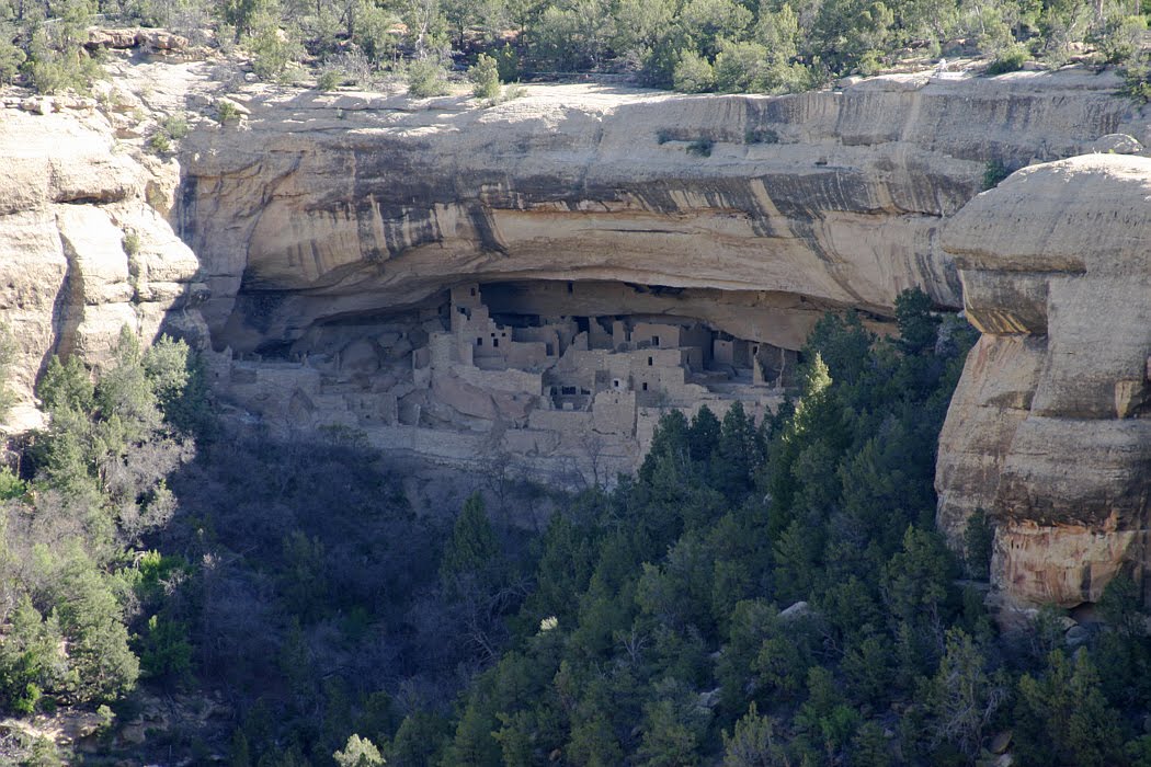
Mesa Verde seems to lean towards guided tours more than most National Parks, which seems reasonable given the need to protect antiquities. I personally don't care a thing for guided tours, however, so I wasn't sure how much I'd find available to see as I flew through the park solo. The picture above (with its inset) gives you an idea of what Mesa Verde is all about - cliff dwellings. It's the first example I saw and, not knowing how many more I'd see, I was glad it was in full sunlight.

There are probably dwellings on the cliff opposite, but I took this shot to show what the 2000 fires had done to many areas on the plateau above the cliffs.

This shot shows grasses and yucca are the first to come back after the fires. Pinyon and Juniper, in the distance on the left, show where the fires were stopped. One conundrum: if the largest tree in the foreground was thoroughly charred, why do so many surrounding it - though still dead - show so little sign of the fire?

This is Navajo Canyon, looking southeast. It's the widest of the canyons I remember seeing. The others seemed to have been designed to provide for both cliff dwellings and overlooks, with tourists on each side shooting back and forth at the dwellings on the opposite cliff.

When I saw this, I thought, "They missed a good one here. I'm surprised they didn't save it for the guided tours." Of course, that's my prejudice showing. I found out on this speed run that there's plenty to see - and photograph - alone, and the guided tours are a great feature for those who appreciate guided tours. Get over it!

I think all of these next few shots were taken of dwellings on the Mesa Top Loop, and show how extensive the building was.


Though there were guard rails at the cliff tops in some of the previous shots, I think this is the only place I actually caught tourists in the picture. On top of the cliff to the left there are a couple at an overlook, and at the base of the ruins you can see a guided tour. Nobody in the tour has a red jacket. That strikes me as strange.

This is simply a shot of the edge of the fire damage, showing how much it changed the local environment. The contrast between the shaded, cool, green forest and the stark destruction of the burned area was intense - ten years after the fire!

This last shot is looking east-northeast over the Mancos Valley towards the La Plata Mountains, a subset of the San Juans. The picture might represent leaving behind the ancient past of the cliff dwellings and destruction of the Mesa Verde fires for the future and areas unaffected by the 2000 fires. But really, it just marked the end of my 2010 photo tour. It's time to stow the cameras and attack the 900 mile drive home.

Sunday, May 23, 2010

Grand View And The Green River Side

Well. . . this is awkward. . . I've been playing with Google Maps and Hey, What's That? much of the afternoon and all evening, and determined that I had made an error in my description of the last picture of yesterday's post. I had mislocated the Orange Cliffs overlook, so misidentified some landmarks. The feature in the middle of the picture is Ekker Butte (6226 ft). On the left, in the middle distance is Elaterite Butte (6552 ft). The mountains on the horizon are, indeed, the Henry Mountains. So, where's Cleopatra's Chair? About a quarter of the way in from the right edge of the picture - the yellowish feature standing above the horizon. Sorry 'bout that. Sometimes my enthusiasm confuses me and I consider myself lucky when I catch my mistakes.

I'll try not to let my enthusiasm run wild with today's pictures. The picture above is looking east-northeast at - what else - the La Sal Mountains from the parking area of the Grand View Overlook.

This is nearly the same view, but the viewpoint has moved south to the overlook itself. The tear in the earth's crust at the bottom right isn't as frightening as the one at Buck Canyon - it's not aimed at us - but it leads to Monument Basin, southeast of Grand View.

This shot is from the same spot, but looking south. The canyon is the west wing of Monument Basin. I'd love to tell you what that lone peak is a bit right of the center, but I haven't figured it out yet. . .

If the La Sal Mountains are anywhere around, it's hard not to make them the center of attention. The viewpoint here is halfway between Grand View and Buck Canyon overlooks. On the near floor in the foreground, Buck Canyon is on the left and Gooseberry Canyon on the right.

This is the western side of the Island In The Sky - the Green River side; Candlestick Tower (5865 ft) is at the right. And, if you look closely, to the left of the tree is Cleopatra's Chair.

Here's another of those rents in the Earth's crust - this one from the Green River overlook. Guess what river that is in the center. On the right is Cleo's Chair again, and to the left of center are Ekker Butte and Elaterite Butte.

Here's a zoom in for detail of the Green River. No additional information here. . .

This is a nice, pleasant view, which should be enough. Unfortunately, I now have a feel for the geography - if not the geology - of the area and I can't let it go. Left of center there's a string of features - at least their tops - about 1/4 of the way in from the left. Closest is the Candlestick Tower, next is Ekker Butte, and then Elaterite Butte, between them. Oh! And Cleopatra's Chair is here again - near the right edge of the picture.

That will have to do for now. . .

Saturday, May 22, 2010

Hey, What's That?

I stayed up late last night preparing today's earlier post which, in turn, gave me license to stay abed through most of the morning - ah, retirement. So, when I did finally waken, read awhile, and have my breakfast, I went back to the computer to wander about in search of new and wondrous things.

I came across a Google Maps page which, is not affiliated with Google Maps, but is kind of a clearing house for websites that incorporate Google Maps somehow for all sorts of interesting things. I found one especially interesting one - so far. After having used a map in my post yesterday to show the alignment of the Colorado River and the canyon through which it was running with the La Sal Mountains in eastern Utah, I just have to show you this.

Hey, What's That? is an interactive website that allows you to define a viewpoint. A couple of minutes after you submit it, the program spits out a graphic panorama, that includes highlighted mountain peaks that are within view (i.e., named peaks [features?] from the Google Maps database that are not hidden by surrounding terrain). It also provides a list of the peaks and, when you select one, repaints the map with the direction, line of sight, distance, and elevation of the peak. There appears to be much more to explore here, so I'll drop this and let you explore it yourself if you're so inclined. I've included portions of two screen grabs to provide examples.


The first (above) is similar to the map I included in yesterday's post. The second (below) represents the results of the manual steps I went through last night to describe the Henry Mountains from the Orange Cliffs Overlook in the Island in the Sky section of Canyonlands.


Now, how's that for a neat trick?

Dead Horse Point and Canyonlands

After picking up a sandwich in Moab I drove up onto the plateau to eat lunch. First stop - Dead Horse Point State Park. The name of the park wasn't that appetizing, but view from the visitor's center was good, and reasonably conducive to good digestion. The two lakes are are next to a place called Potash, so my guess is they're pools having to do with the production of potassium at the plant nearby. On the horizon are the La Sal mountains, about 27 mi due east.

This picture is looking south from the Dead Horse Point overlook (6000 ft) at a couple of bends in the Colorado. The river is about 2000 ft below the overlook. The biggest trouble with a trip like this is, it's basically a one-shot deal. You don't have the luxury of waiting around for the clouds to show up - or leave - or, even more importantly, for the light to change. I was here in the early afternoon. Sunrise or sunset would have been nice.

After 45 minutes or so in the state park, I backtracked a few miles and took the fork leading into Canyonlands National Park. The focus of Canyonlands is the confluence of the Green River, flowing from the north, and the Colorado River, coming in from the east-northeast. The V-shaped portion of the Colorado Plateau bounded by the rivers (you are Here) is called the Island In The Sky. As the merged river (Colorado) flows south, it separates the two other portions of the park - the Needles district to the east and the Maze to the west.

The picture above is the view looking east to the La Sal Mountains from Shafer Canyon Overlook. You can't see it in the picture, but to the left there's a dirt road from the plateau down into Shafer Canyon and (eventually) to the Colorado with more switchbacks than any reasonable person would ever undertake. And, of course, there are hiking trails all over the place. See the people out near the point? Going out there crossed my mind, but then I remembered the Black Canyon - the notion that there might be a "View" down there, quickly passed.

This view looks south-southeast down the eastern edge of the Island In The Sky from  Buck Canyon Overlook. The mountain range on the horizon to the left of the tree is the Abajo Mountains and is similar to the La Sal Mountains and the Henry Mountains in that each of the ranges was "formed about igneous intrusions" in the Colorado Plateau between 22 and 27 million years ago. These intrusions are relatively resistant to erosion; their isolation from other ranges makes them all the more impressive when you happen upon them, and all the more interesting when you see them in the distance.

Still at Buck Canyon Overlook, this eastern view towards the La Sals is startling, to say the least. Maybe it's just the angles, but my first instinct on seeing Buck Canyon was to look closely and assure myself the Earth wasn't - still - in the process of opening up. I determined that it is safe for tourists and there's little danger that they'll be swallowed up while taking their pictures.

This shot is looking west-southwest from the Orange Cliffs overlook. The mesa in the middle distance in called Cleopatra's Chair, about 6200 ft. Directly behind it, on the horizon, is the third range of igneous intrusions in the Colorado Plateau, the Henry Mountains. No, they're not clouds. The highest peak, Mt Ellen, is 11,506 ft and about 55 miles away. The Henries were named by John Wesley Powell for Joseph Henry, first secretary of the Smithsonian Institution. They were also the last mountain range added to the map of the 48 contiguous states (in 1872).

Friday, May 21, 2010

The View

There are only a few places I've come across in my travels that provide a "perfect view" - a view so impressive you probably couldn't improve it. I described one in my post on Yosemite. I think there's another attribute, however, that's even more important. The view has to be so good you probably can't screw it up! (I say "probably" only because some people can screw anything up.) On this trip I found another "perfect view".

I even provide a Treasure Map so you can find it next time you're out driving around near the Colorado/Utah border country. It's a Google Map, of course - I bless Google every day - and I've added some notations. First, in the upper right, I show where UT 128 joins the Colorado River and the canyon starts, because I mentioned that in yesterday's post. Then, I added a blue sight line to show the canyon is perfectly aligned with the peaks of the La Sal mountains, 16 to 18 miles south-southeast. Finally. I labeled three viewpoints in the two and a half mile long canyon and the closest peak of the mountain group.

Now, the real Treasure. . .

When I rounded the curve the view took my breath away and I stopped as soon as I could find a wide enough shoulder to pull off on. As soon as you're past the immediate valley, the successive layers of varied geology lead your eye to the snow-capped peaks of the La Sals. A Perfect View. But, like Lays Potato Chips, one just won't do. You don't want to get back in the car and you don't want to stop taking pictures - just in case.

So, your zoom lens lets you vary some details, but the "Perfect View" still holds.

It's a good thing traffic on 128 is so light. Every time you glance at the road, then look back at "the View", your car seems suddenly, of its own accord, to veer to the side of the highway and come to a screeching halt. Better get out and take a few more pictures; some of the nearby details have changed, obviously, and could give you a better shot. But "the View" is the same.

If your purpose for being there is to take pictures anyway, you may as well give in to the urge and take every opportunity to shoot as you and the Colorado make your way down the valley.

I generally like to crop this type of picture to eliminate "cultural features" (e.g., roads, signs, buildings, etc.), but even the highway and a Land Cruiser can't screw this up. It may or may not be as good as the one before or the one after. . . but it ain't bad.

As much as I've gone on in previous posts about the clouds and "interesting skies", I have to confess that, "if I'd had my druthers", the skies would have been a bit less interesting this particular day, at least till I'd cleared the valley.

Thursday, May 20, 2010

Colorado - the River

I escaped Grand Junction's morning rush hour - such as it is - and found myself virtually alone on I-70, headed to Utah. After about 45 mi, I discovered a 2 mile positional discrepancy in the map database my GPS uses - and missed my turn-off because of it. Another 10 mi to the next exit - this is a RURAL interstate after all; Utah, you know - and the discrepancy was still there but, being flexible, I took the exit anyway.

I stopped as soon as I crossed to the south side of the interstate to get this picture of the La Sal Mountains, about 28 mi south in the very direction I was headed. I had been eyeing this anomaly as I drove, for about the last 25 mi, but wasn't really sure where it was in relation to my planned route. As it turned out, it's about 17 mi ESE of  Moab and dominates many of the area's vistas - as you'll see later. There are several peaks, the highest of which is 12,721 ft. My viewpoint elevation was about 4400 ft.

Eight or nine miles SE of that first viewpoint my route brought me to the banks of the Colorado River and I followed the river on UT 128 into Moab for lunch.The picture above is typical of the land along the Colorado from here all the way past Hoover Dam, though the flooded areas of Lake Powell and Lake Mead are farther afield and much more varied.

At this point - or, at least, now - the Colorado appears pretty lazy and isn't much like John Wesley Powell described his trip down the river in 1869. I saw four rafts that morning, two groups of two. What was interesting about this drive was that the road followed the river from the very beginning of the canyon. There are some wide spots, but for the most part the canyons just keep getting grander and grander as we went downstream. . .

The wall above was different than most on this drive. It reminds me of many of the walls that constrain Lake Powell. From my visit there in 2008, I remember that the chocolate colored stains on the wall are from manganese.

This one caught my attention because of the massive fracture pattern, the sheer wall, and the highlights of the sun with deep shadows.

Wednesday, May 19, 2010

The Black Canyon of the Gunnison

It's amazing, isn't it? I mean this is the early afternoon of the first day out of Cortez. Lots to take pictures of. Northwest out of Ridgeway and headed for Montrose. I've been to Montrose before. Fourth of July, 1976 we were headed back to California. Spent the night in Gunnison, watched bicentennial fireworks at local college, and headed for Montrose the next morning. On the way we took a side trip to see the Black Canyon of the Gunnison. I decided to include the Black Canyon on this trip "for old times sake".

The elevation of Montrose is about 5800'. This picture was taken several miles east northeast of town, looking east from CO 347, which climbs to the National Park atop Vernal Mesa [about 8200']. The northern edge of the mesa coincides with the southern edge of the Black Canyon. The northern edge of the canyon is formed by the Mesa Inclinado - have you got that? It's the clouds I'm excited about. I'm hoping this build-up means a cloudy day tomorrow when I get to Utah.

This shot was taken at Pulpit Rock overlook - looking north I think. I was pleased when I got here, sure that this was where I had taken several pictures in '76 - and that I actually recognised it after 34 years. It's hard to see, but the river is visible in two places waaaaay down there.

You can see it here a bit easier. The river's about 2000' below the edge of the canyon. I can't be more specific because, while the mesa's reasonably flat, the river drops on average 96'/mi over its forty-eight mile run through the National Park. It drops more in that forty-eight miles than the Mississippi does over its entire 1500 mi run from Minnesota to the Gulf of Mexico. In one two mile stretch, it drops 480'. Before dams were built upstream, the Gunnison used to dump 12,000 cu ft/sec through the canyon at flood stage. [That's 2.75 million horsepower. . .] Impressive!

This is the view of the overlook from the porch of the visitor's center. It didn't look either that far or that much lower than the visitor's center when I headed out there - and believe me, I evaluate that sort of thing. By the time I'd started back though, I'd remembered one should never climb any farther down than he's willing to climb up. I kept that in mind the rest of the trip.

This is one view from the offending overlook. It's nice and sharp because, at the time, my breathing was more or less normal. Climbing back to the visitor's center took a lot out of me, but I guess it was worth it - it didn't kill me.

By this time I was completely turned around; you'll have to guess what direction we're looking and, while you're at it, what mountains those are in the distance. I can't help you. I'm fairly sure I'm still on the south side of the canyon, so that'd be Mesa Inclinado across the way, and it's a pretty good view.

Ah, there's the river again, headed west northwest out of the park on its way to Grand Junction, where it joins the Colorado. Note the clouds aren't nearly as interesting out there as I'd hoped. . .

Of course, the South Rim Road just ends at High Point so you have to backtrack to get out. That's why I found myself back on CO 347 shooting those mountains to the east again. In case you're wondering this picture and the first in this post were taken an hour and fifty-four minutes apart. These clouds notwithstanding, I'm thinking it's going to be clear in Utah tomorrow. . . RATS!

Tuesday, May 18, 2010

Back to Telluride

Having given up on making it around the ridge because of the "road conditions" on Last Dollar Rd, I turned around and headed back to Telluride, or at least to the Telluride highway. From a photographer's point of view, there's a lot to be said for retracing your footsteps - or your tire tracks in this case. You drive till something catches your attention and you can find a place to pull over. You get out, shoot whatever it was that caught your eye then, if you're smart, you look all around for anything else of interest - click, click, click. But you still miss an awful lot, surveying only what's in front of you during the time you're driving. By going back the way you came, you get another chance at all that real estate. . .

I'm not quite sure what it is about the picture above - maybe the orange stakes - but I like it.

Recognize these mountains? Yeah, me too. But I missed this composition the first time, probably thinking about the barns I'd just passed. So, I stopped on the way back for the next picture, and found this nice, suitably rustic fence AND a bale of barbed wire.

Here's one of the barns I mentioned - the others are up the slope a little bit. But I was thinking about a composition for a painting, and wanted to get close enough for some detail. What do you think, Stephen?

Alright. Back out to the highway; down the road several miles alongside the San Miguel River and hook a right on Colorado Hwy 62 out of the valley - or at least out of this valley.

This is a view looking east on the road to Ridgeway. Coincidentally, it was taken from the intersection of Last Dollar Rd and CO 62 - where I would have joined the highway if Last Dollar had been passable. The sky kept getting more and more interesting throughout the afternoon.

This was taken at the same stop, but looks southeast. Nice scenery, a good sky - it gave me a sense of the winds aloft and reminded me for awhile how much fun flying used to be. I never flew up here, but I'll bet it would have been great.